Based on NASA satellite images, scientists have tracked how river sediments have changed. They analyzed the volumes of solid particles they carried into the sea and found a significant difference between the two hemispheres of the Earth.
Satellites study global ecology
Scientists used data from NASA satellite images and digital hydrological archives to estimate changes in river flow over the period from 1984 to 2020. Most of all, they were interested in the volume of sediments when rivers carry out solid particles of soil and settle near their mouth in the ocean. At one time, similar processes formed formations on Mars, which are now being studied by the Perseverance rover.
Scientists have previously conducted similar long-term studies of global changes in other ecosystems, comparing satellite images over the past few decades. In particular, it was thus established that warming in the Alps manifests itself primarily as the appearance of vegetation where it did not exist before. And it seems that the study of the floodplains showed that they disappear primarily in East Asia.
The last is particularly interesting to compare with the results of the current study. Scientists analyzed 414 rivers around the world. It turned out that in the Northern Hemisphere, river deposits are decreasing, and in the Southern Hemisphere, on the contrary, they are growing strongly.
How river sediments change
In order to understand what caused these differences, scientists studied satellite images in more detail. Special attention was paid to the color of river water. Color in general can tell a lot about the reservoir, no wonder it was even translated into music.
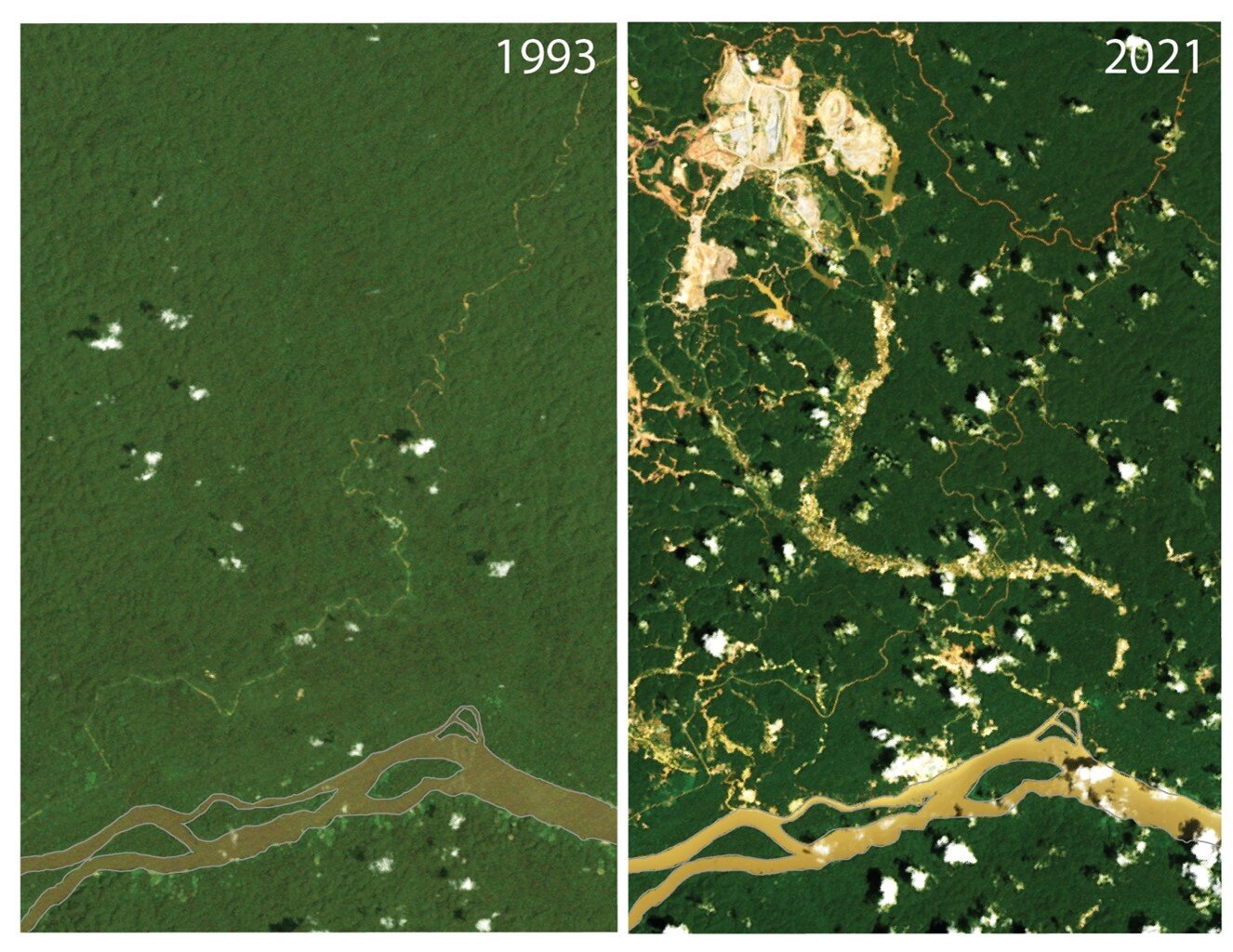
An example here is the Maroni River, which flows in South America. Its satellite images of the 90s show a dark brown or dark blue color. Now its waters have a yellowish-brown color. The reason for this is easily found in the massive deforestation and mining of minerals in an open way, clearly visible from satellite.
Geospatial information, that is, information about changes in the state of objects in relation to other important terrain details, has become the main topic of modern satellite surveillance. And it is used not only in the military and business spheres.
It is also very easy to track the causes of environmental changes with its help. So scientists saw the destructive activity of people, which accelerates the destruction of soils next to all the rivers that have turned yellow from sediment.
South and North
Human economic activities in the Southern Hemisphere include timber cutting in Malaysia, open-pit gold mining in Africa and South America, and palm plantations in most of Oceania. All of them lead to an increase in the washout of the shores, which the satellite sees well. As a result, the amount of sediment in the Southern Hemisphere has increased by 36 percent since 1984.
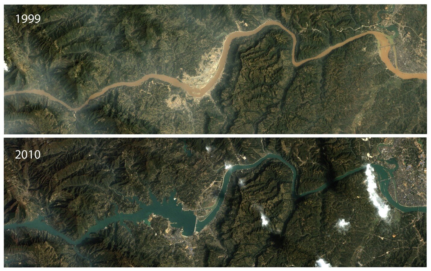
The reasons for the decrease in deposits in the Northern Hemisphere are also clearly visible from satellites. The main reason that since 1984 the volume of sediment has decreased here is the construction of dams containing solid particles. There are more than 90 thousand of them in the USA alone.
At the same time, it is clearly noticeable that it is in the developed countries of Europe and America that river flow has not fallen too much over the past 40 years. After all, most of the dams were built here before the middle of the XX century. But in East Asia, this process continues to this day. This causes a significant decrease in the volume of sediment and is well consistent with the disappearance of the fins.

Why River Sediments are important
The problem of changes in river sediments is ambiguous. On the one hand, the increase in sediments indicates the destruction of fertile soils, which may threaten the planet with global famine in the future.
On the other hand, together with solid particles, a large amount of organic remains is carried out into the oceans. Thus, rivers play an important role in the implementation of the carbon cycle. Violation of it may threaten to accelerate global warming.
Finally, for many coastal countries, river deposits are a natural way to increase or at least preserve their own territory. The water level in the world’s oceans is rising and in countries such as the Netherlands, Vietnam or Bangladesh, sediments compensate for it.
According to phys.org
Follow us on Twitter to get the most interesting space news in time
https://twitter.com/ust_magazine
