

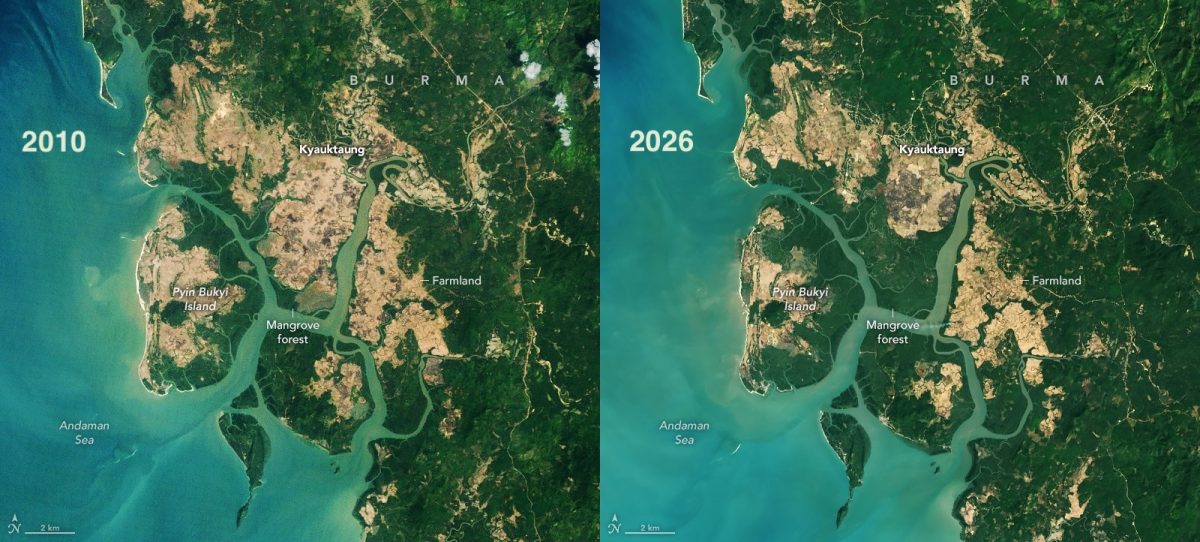
After several decades of decline, a turning point came about a decade and a half ago, and since then, the area of mangroves worldwide has been increasing. Most of this growth has come not from tree planting but from the natural colonization of new areas. This is clearly visible in NASA satellite images taken over the coast of Myanmar in 2010 and 2026.
Forty years of satellite images
Between 1984 and 2010, the world lost almost 3,000 square kilometers of mangrove forests. For comparison, the area of Kyiv is about 840 square kilometers. After 2010, mangrove coverage increased by almost 2,000 square kilometers. Thus, even after the recovery of mangroves, the planet still has approximately 1,000 square kilometers less than it did in 1984.
These estimates were obtained by a team led by Zheng Zhang, an environmental researcher at Tulane University in the United States. The scientists tracked changes in the area and density of mangrove forests using images from Landsat satellites between 1984 and 2023. The results were published in the peer-reviewed journal Science. According to Zheng Zhang, these are the first global maps of mangroves covering such a long period, as long-term changes had previously been studied only in individual regions.
Mangrove ecosystems store up to four times more carbon than upland tropical forests. They protect coastal settlements from erosion and storm surges, while juvenile fish, shrimp, and crabs grow among their stilt roots.
Where new forests come from
Approximately two-thirds of the increase came from mangroves colonizing new areas, while only one-third resulted from the restoration of degraded forests. Near the mouth of the Amazon River and in northern Australia, river sediments have formed muddy shoals, which mangroves have been gradually covering since the 1990s.
Mangroves grow in the tidal zone, which is regularly flooded by saltwater. As soon as a mudflat rises high enough, seedlings carried by currents take root there. At the northern and southern boundaries of their range, including the southeastern United States, a different factor is at work. Warmer winters with fewer frosts have allowed the trees to expand into areas that were previously too cold for them.
Forest density has also changed. In many forests, the canopy is now denser than it was in 2010, which is a sign of healthier forests, particularly in South America.
The example of Myanmar
The reversal is most clearly visible in Myanmar. During the 1980s and 1990s, the country was rapidly losing mangroves due to agriculture, aquaculture, and firewood harvesting. By 2010, their area had decreased by 28.6%. Since then, it has increased by approximately 10%.
The authors attribute this turning point to several factors. Following the 2004 Indian Ocean tsunami, greater attention was paid to forest restoration, legislation strengthened their protection, and rivers brought in so much silt that new mudflats formed. Images released by NASA Earth Observatory show how mangroves in the south of the country expanded between 2010 and 2026, while neighboring fields shrank. However, logging remains widespread there.
Where forests are still disappearing
The increase is not occurring everywhere. In the Niger Delta, losses have been so extensive that the total area of mangroves in West and Central Africa has decreased since 2010. In North America and southern Africa, large areas have been degraded following tropical cyclones.
Zheng Zhang warns that these gains should not lead to complacency. In his view, a significant positive effect will come from combining natural expansion and forest restoration with the protection of existing mangroves and a reduction in deforestation.
