
The European Space Agency (ESA) has published images taken by the Sentinel-2 satellite. They demonstrate the process of disappearance of the remnants of the Aral Sea.

The Aral Sea, located on the border between Kazakhstan in the north and Uzbekistan in the south, was once the largest body of water in Central Asia. In 1960, the lake had an area of about 68,000 km² — twice the size of Belgium.
Until the 1950s, the water level in the Aral Sea remained stable thanks to the Syr Darya and Amu Darya rivers. They brought fresh water to this temperate oasis located in a largely arid region. In the 1960s, however, they were diverted to irrigate cotton fields throughout the region. Since then, the Aral Sea has begun to rapidly shoal and shrink in size. By the end of the 1980s, it had already split into two reservoirs — the southern one (the so-called Large Aral), common to Kazakhstan and Uzbekistan, and a smaller, almost unrelated lake in the north (the Small Aral), in Kazakhstan. By 2001, the Large Aral had split into two more parts.
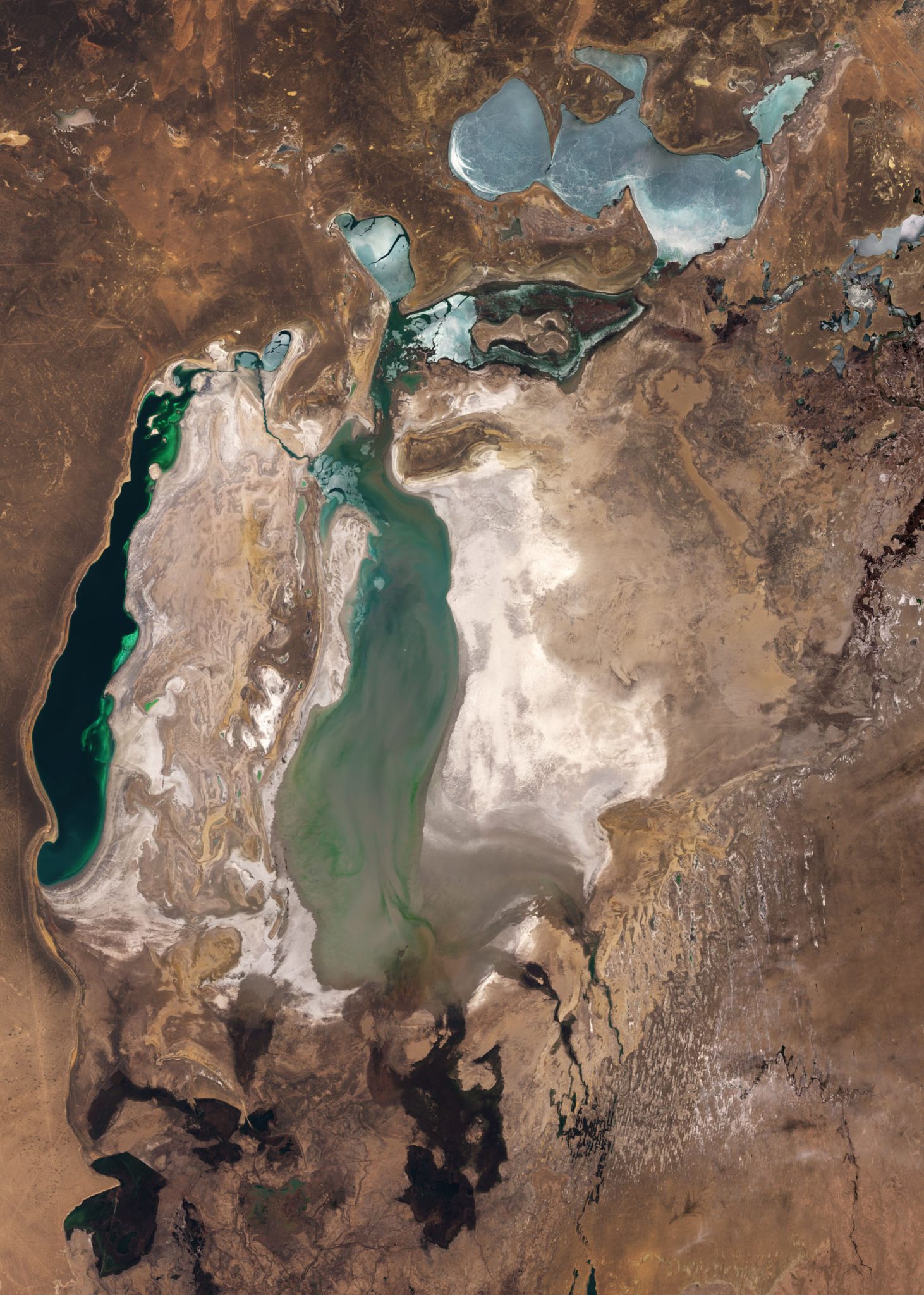
An image taken by the Sentinel-2 satellite in March 2025 shows that the western part of the Large Aral Sea has shrunk considerably, while the eastern part, still visible in the 2018 image, has almost completely dried up. When the Aral Sea evaporated, it left behind an area of dry, salty terrain. In the satellite image, it appears as a whitish area over the former lake bed. It is now the Aralkum Desert, the youngest desert on Earth.

The retreat of the water has destroyed the once thriving fishing industry in the area and changed the regional microclimate. Severe sandstorms have become a common annual occurrence. They carry tons of salt and sand from the bottom of a dried up lake for hundreds of kilometers. This causes serious health problems for the local population and makes winters colder and summers hotter.
At the northern tip of the western part of the Great Aral, you can see the remains of something that looked like an emerald green heart-shaped body of water in 2018. This body of water is also receding and will likely disappear soon.
The ice-covered waters of the Small Aral Sea can be seen in the upper part of the image. While the entire southern part of the lake is expected to dry up completely soon, the Small Aral Sea is at the center of international efforts to preserve its remnants. The two brown straight lines at its southeastern end correspond to the Kok-Aral dike. It was built to stabilize the water level and salinity and prevent it from overflowing into the southern part of the lake. Since the dike was completed in 2005, the water level in the Small Aral has risen by an average of 4 meters.
According to ESA
