February 24, 2022, began with explosions in Ukrainian cities. Russian aggression, which had been going on since 2014, became full-scale. However, our country did not surrender then and has continued to hold out for three years. This is evidenced by numerous satellite photos that have captured everything that has happened during this time.
The Russian invasion
In February 2024, many people said that Ukraine was unable to resist Russia and had no choice but to make concessions and seek peace. At the same time, it is somehow forgotten that the full-scale invasion of Putin’s dictatorial regime has been going on for 11 years and has been going full steam ahead for 3 years.
Optical and SAR satellites have been recording large-scale movements of Russian equipment and the brutality of Russian army soldiers all along. But even more importantly, they show that Ukraine was unafraid of all this. It repelled a large-scale invasion in February 2022 and continues to resist to this day.
Source: Maxar Technologies
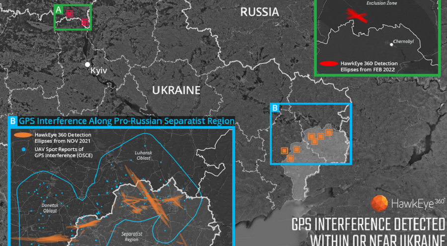
The fact that Russian troops are preparing for an invasion was noticed not only by satellites that monitor the optical range. HawkEye 360, a company whose devices monitor the operation of navigation systems, registered problems with GPS both in the already occupied territory of Donbas and along Ukraine’s northern border. It was clear that this was due to electronic warfare.
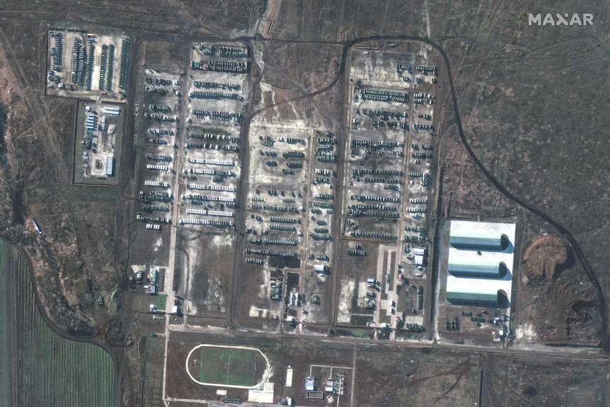
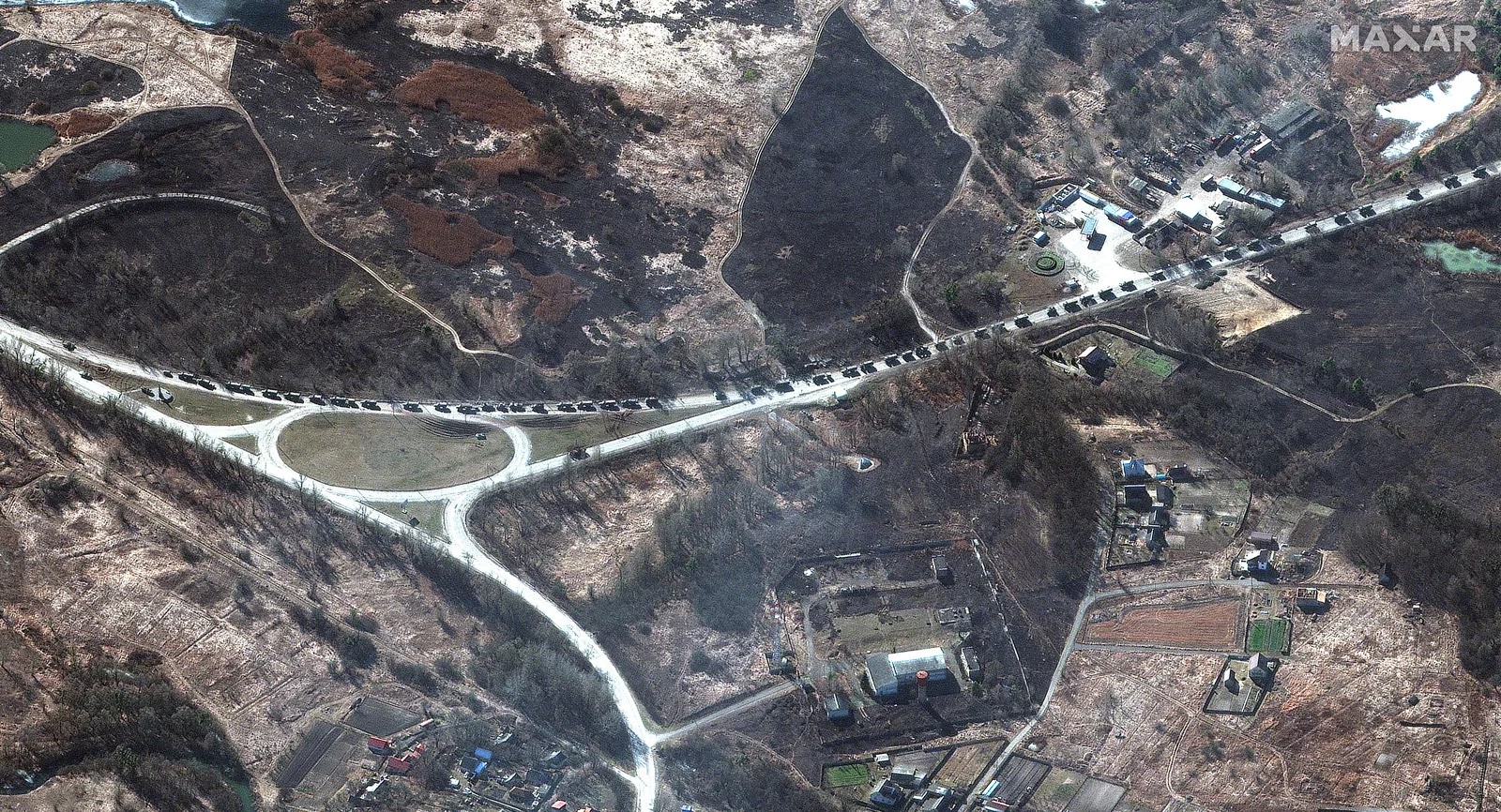
All of these suspicions were confirmed on the morning of February 24, when huge columns of Russian vehicles crossed the Ukrainian border and moved toward major cities. One of the largest stretches from Belarus to Kyiv. The satellites saw it so well that they were able to distinguish even individual trucks and assess their condition in general.
The Russians acted extremely clumsily. Therefore, Ukrainian troops, who took up a maneuverable defense, were able to inflict devastating losses on them. They were able to act quickly and accurately thanks, among other things, to satellite imagery, which allowed them to track the enemy’s movements.
In these circumstances, Ukrainian entrepreneur Max Polyakov addressed the global space community. The well-known figure in the field of private space exploration called on commercial companies Planet Labs, Maxar Technologies, Airbus, SI Imaging Services, SpaceView, BlackSky, Iceye, and Capella to provide free access to their images to the Ukrainian military.
The emotional 20-minute speech became one of the bricks that laid the foundation for foreign countries’ trust in Ukraine in this war. In addition, Max Polyakov’s EOS Data Analytics company signed an agreement with GEOSAT, and thus Ukraine de facto became the owner of the GEOSAT-2 multispectral optical satellite.
Later, images from commercial companies began to appear regularly. And they did not always bring good news. For example, on February 28, one of the photos confirmed the destruction of the world’s largest airplane, the An-225 Mriya, by Russians. It fell victim to the fighting for the airfield in Hostomel, which the Russians were trying to use as a springboard for their landing.
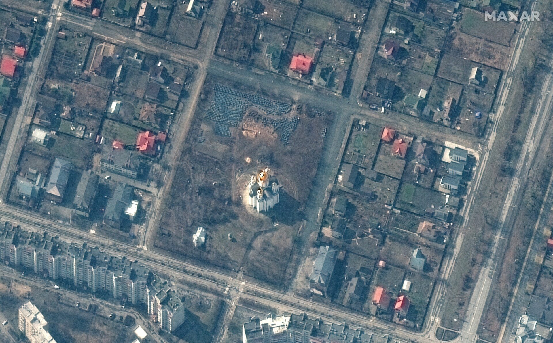
In the end, the Russians were driven out of the Kyiv region, and the world learned about the terrible consequences of their stay in Bucha and Irpin. However, the aggressor country tried to shift the blame for the civilian killings to Ukraine.
However, it was here that the ability of commercial satellites to photograph the same area of the Earth many times over a month played a role. Thanks to this, not only investigators but also ordinary people were able to see with their own eyes when the bodies of the dead appeared on the streets and in a mass grave near the church.
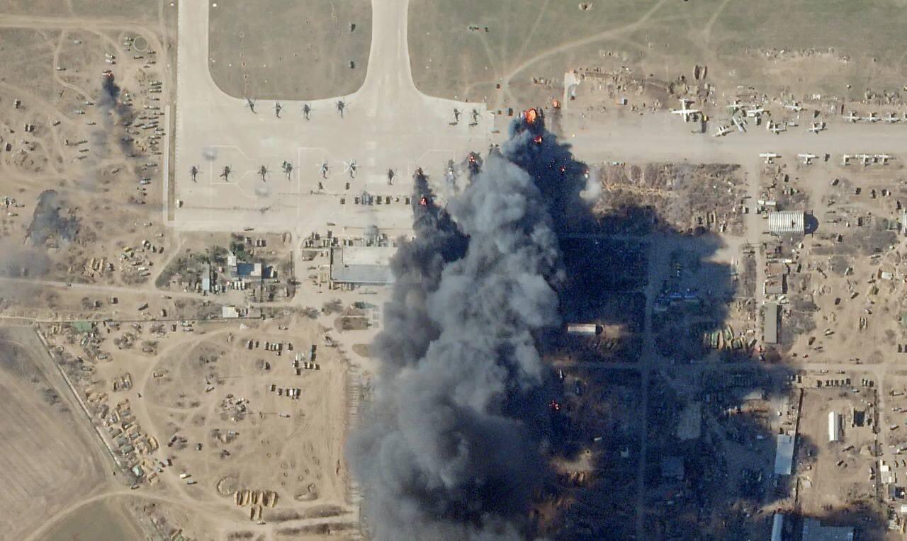
At the same time, the first satellite images began to appear, showing damage to Russian equipment. An example of this is the photo of Russian helicopters burning at the airfield in Chornobaivka, which later became extremely famous. Thanks to these images, it was possible to refute Russia’s propaganda lies that its offensive was going according to plan and with virtually no losses.
Mariupol
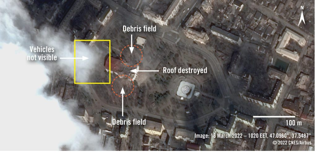
Then the war gradually retreated from Kyiv. However, in the east and south, it was only gaining momentum. Mariupol became one of the hottest spots in the spring of 2022. Now Russia is trying hard to hide the brutality with which it stormed the city. However, satellite imagery on Google Maps has preserved the appearance of a city theater where civilians were hiding, which was destroyed by the Russians.
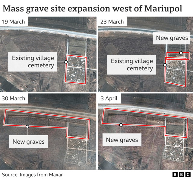
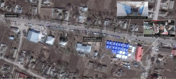
In addition, in the spring of 2022, satellite imagery appeared that helped to establish the impact of the war on the civilian population. Thanks to constant surface photography, it was possible to record how a new cemetery was growing near Mariupol. Thus, satellites played an important role in documenting war crimes.
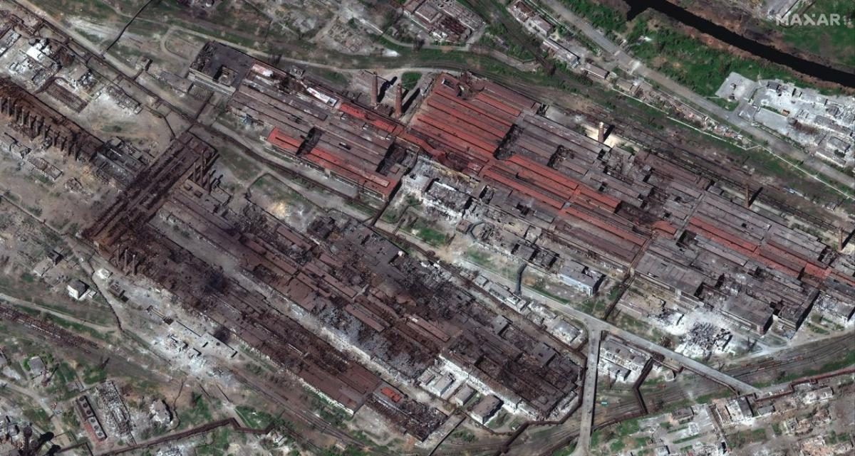
At the same time, the heroic defense of the Azovstal plant continued. The spacecraft was able to show how devastating the Russian attacks on the positions of the Ukrainian defenders were.
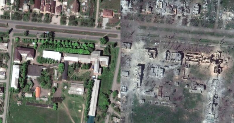
In general, satellite data helped us learn a lot about the behavior of the occupiers in the Donetsk region. Comparing the images from orbit with photos taken on the ground and witnesses’ accounts helped. In particular, it became known that the Russians had set up a network of filtration points and prisons, which were used to identify pro-Ukrainian people.
The prison in Olenivka became one of the key elements of the created filtration system. In July 2022, Ukrainian prisoners died there under tragic circumstances. Once again, satellite imagery helped to establish that the graves of those allegedly killed in the missile strike had appeared a week before.
The Battle for the Black Sea
In the summer, satellite images showed not only Russian atrocities but also their defeats. Back in March 2022, Saratov opened an account of Russian landing ships destroyed by Ukraine.
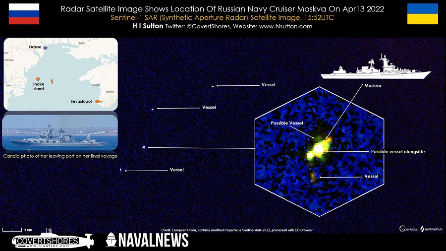
However, it was not possible to capture the destruction of the flagship of the Russian Black Sea Fleet, the cruiser Moskva. It was cloudy over the Black Sea at the time. But the synthetic aperture radar (SAR) satellites came in handy. These devices receive images using radio waves and can therefore “see” through clouds and rain.
One of them was lucky enough to see the escort ships trying to save the missile-damaged flagship.
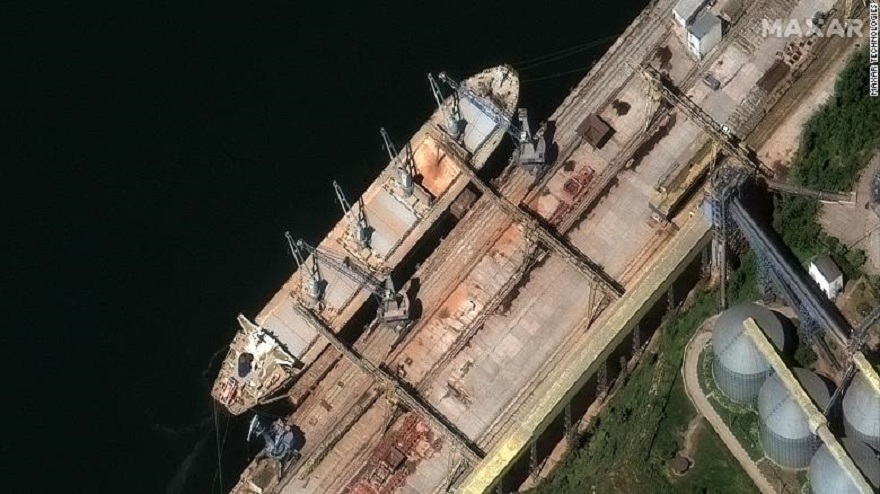
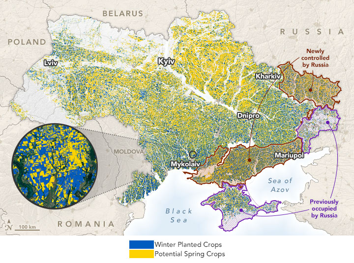
In the summer of 2022, the topic of Ukrainian grain became important. Russia blocked its exports through the Black Sea and gradually exported the stolen grain to third countries. The way the occupiers load it onto ships in Black Sea ports has also been repeatedly captured on satellite images.
At the same time, it turned out that our country is one of the world’s most important grain exporters, and even NASA is closely monitoring the harvest in Ukrainian fields.
Fall 2022
The need for satellite imagery for intelligence was only growing. So in August 2022, volunteer Serhiy Prytula purchased a SAR satellite for Ukraine with funds raised by Ukrainians. Maksym Polyakov again acted as a consultant. For the year, the ICEYE device helped to detect thousands of enemy positions and vehicles.

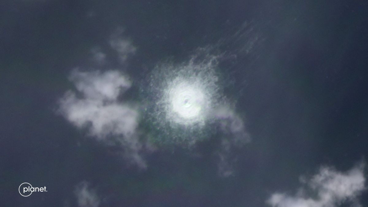
In September 2022, a series of explosions occurred on the Nord Stream subsea pipeline. The results were also seen by satellite. It is still not known for certain what happened there.
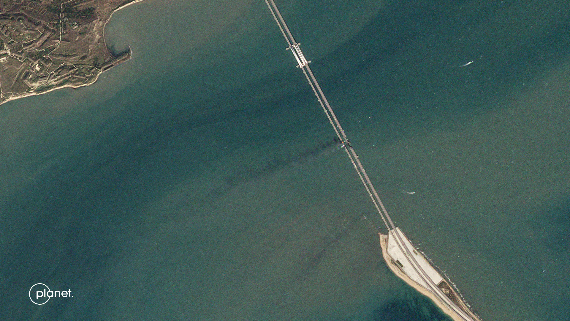
And on October 8, the “bavovna” exploded on the Kerch Bridge, which connects Crimea with Kuban.
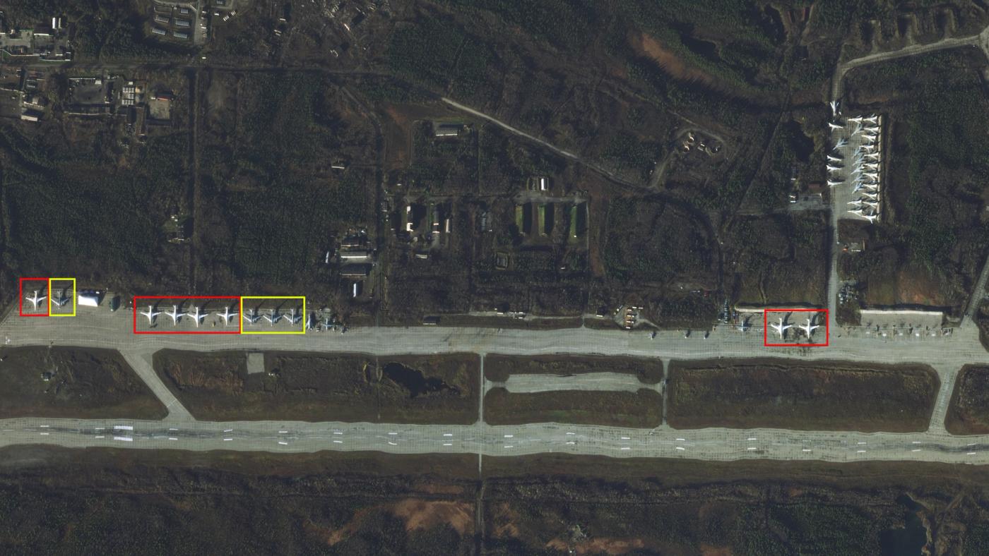
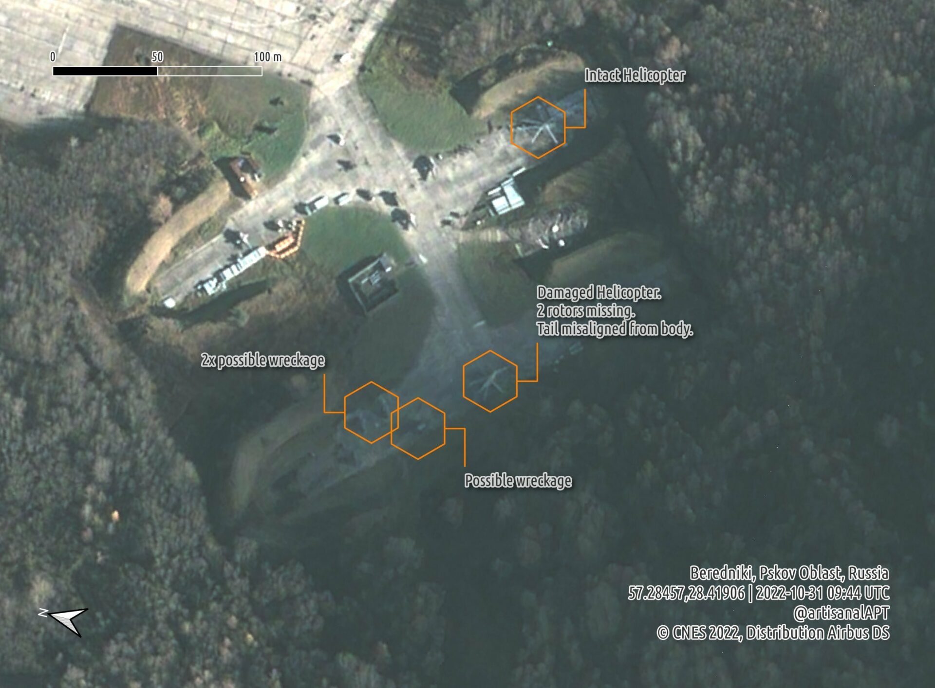
Russian equipment was being spotted everywhere. The terrorist country had just begun to strike at Ukraine’s energy infrastructure, leaving millions of people without electricity and heating in the face of winter. However, neither fighters in the Kursk region, helicopters in the Pskov region, nor bombers above the Arctic Circle could hide from the satellites.
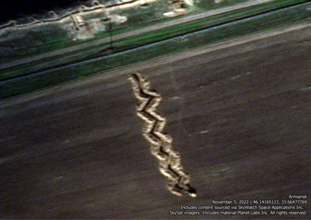
Even before the new year began, it became clear that the Russians were seriously preparing to defend the occupied territories. New foxholes, trenches, and other defensive structures have been registered by orbiting vehicles since the end of the fall of the year before last.
Soledar and Bakhmut
At the beginning of 2023, the main focus was on Bakhmut and Soledar, where fierce fighting was taking place. The images are an example of the village of Opytne, which was already heavily damaged at that time.
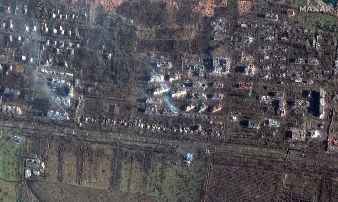
Later, Soledar was also included in the satellite images. The images captured by the orbiter clearly show high-rise buildings that had turned into complete ruins as a result of the Russian military assaults.
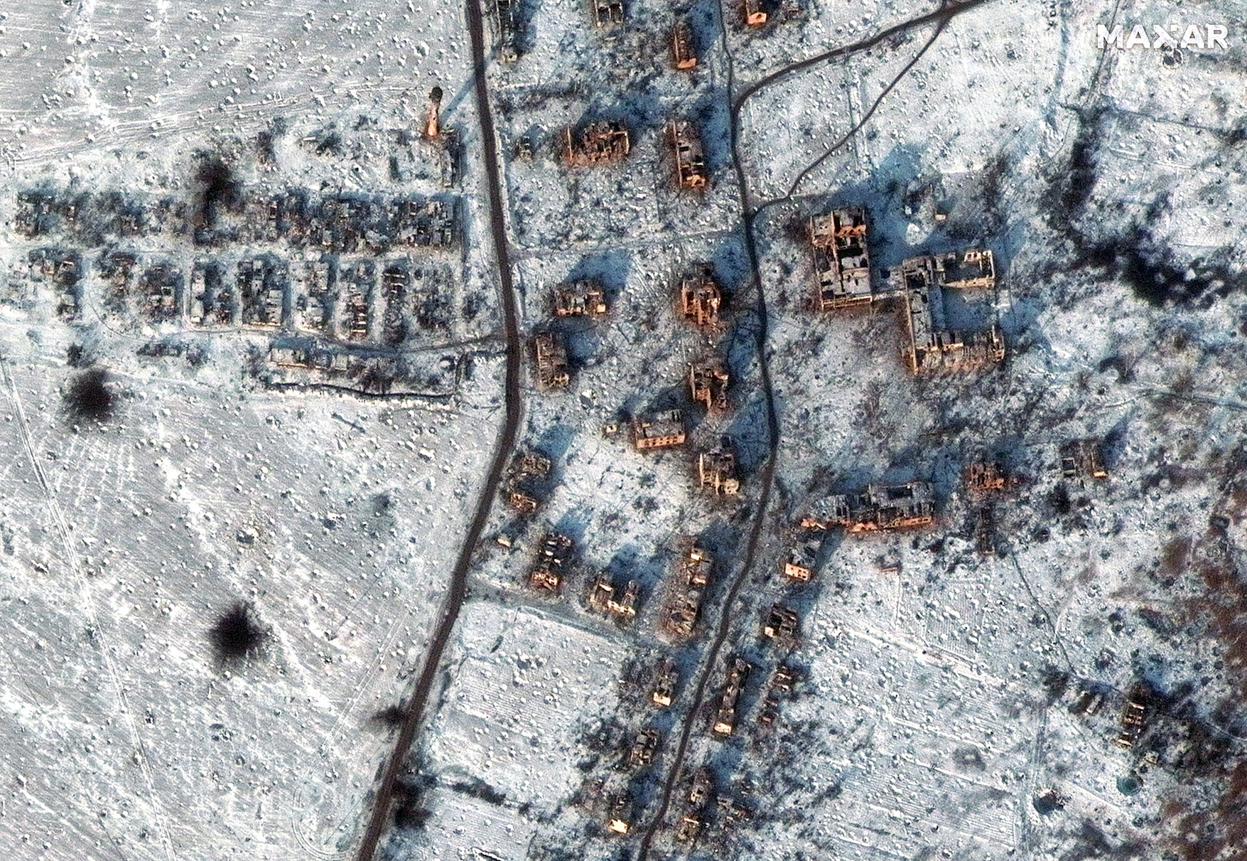
In the spring, the battle for Bakhmut entered a new phase. After months of assault, Russian troops managed to occupy its territory, where most of the buildings had already turned into ruins. This can be seen on satellite images taken in May.
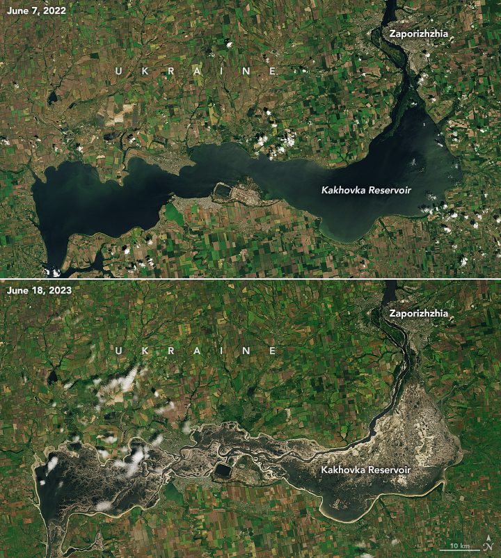
Destruction of the Kakhovka Dam
The summer of war in 2023 began with a large-scale man-made disaster. To prevent the Ukrainian offensive, the Russians blew up the dam of the Kakhovka hydroelectric power plant. This caused a large-scale flood and the destruction of settlements in the Kherson region. All of this was monitored by satellites from private companies in a very timely manner.
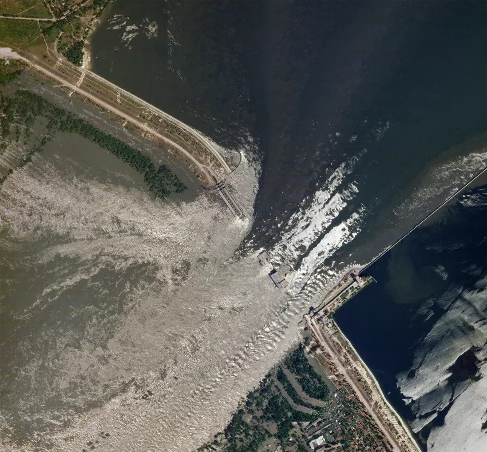
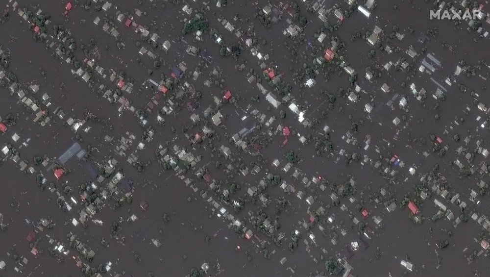
A little later, it became clear that the dam had been destroyed and that the Kakhovka reservoir would soon disappear completely. Experts are still arguing about the consequences of the disaster, but satellite images of what is left of it are impressive.
The fight continues!
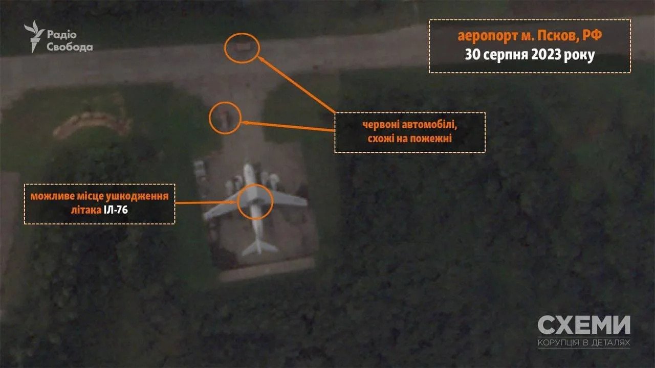
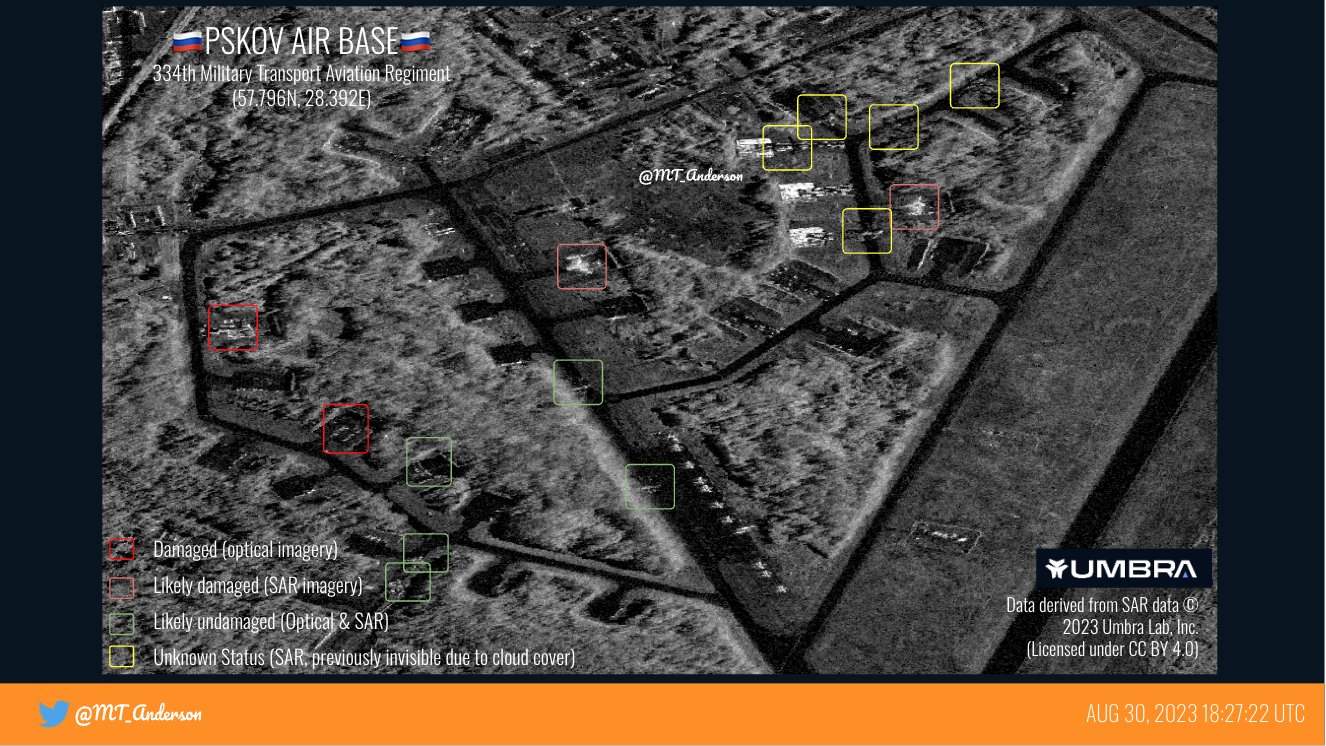
The fall of 2023 began with strikes by the Armed Forces of Ukraine on the occupiers’ bases. As early as September 1, images of the results of the destruction of equipment at the airfield near Pskov appeared.
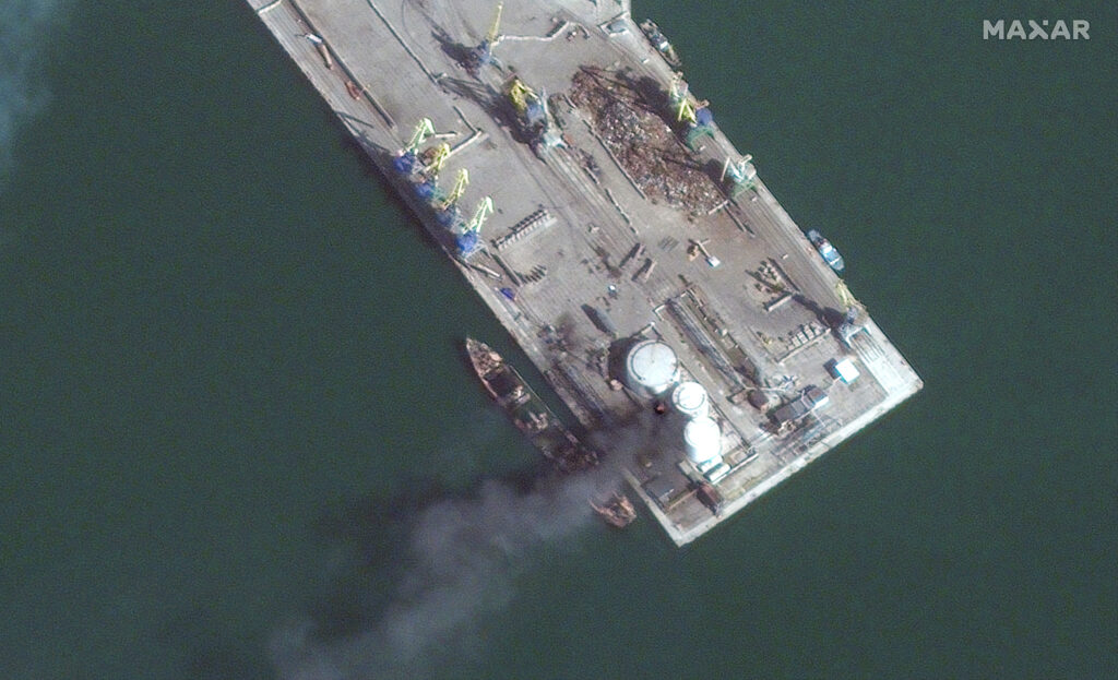
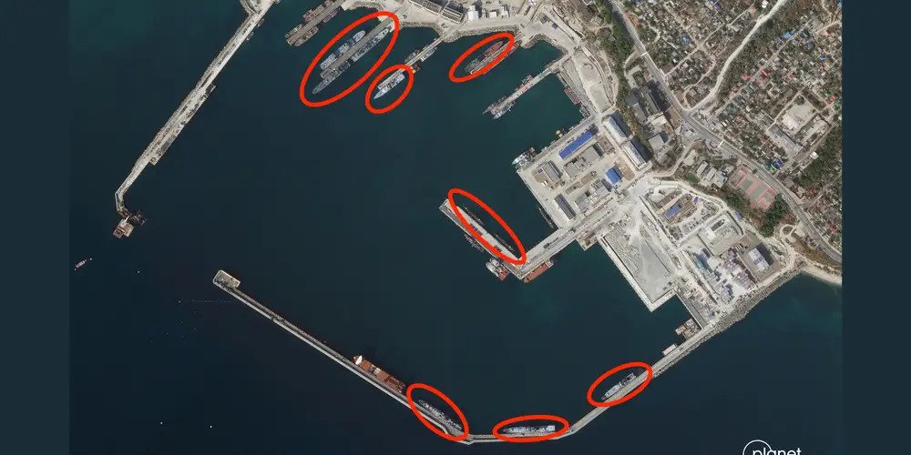
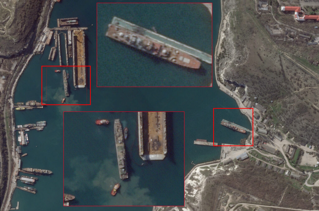
But this was not the end of the matter, it was just the beginning. On September 12, the amphibious assault ship Minsk and the submarine Rostov-on-Don were disabled in the docks of Sevastopol.

On September 13, the S-400 Triumph air defense system was destroyed in the same Crimea.
On September 20, a Russian army command post was destroyed in Crimea.
The results of these actions were not long in coming. Already in October, satellite images showed that Russia had withdrawn most of its ships from Crimea to Novorossiysk, on the Caucasus coast.
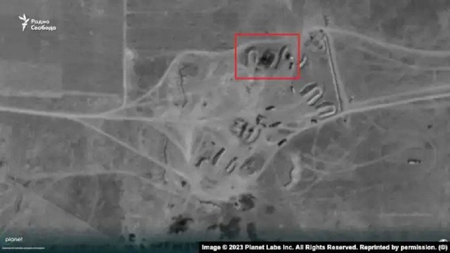
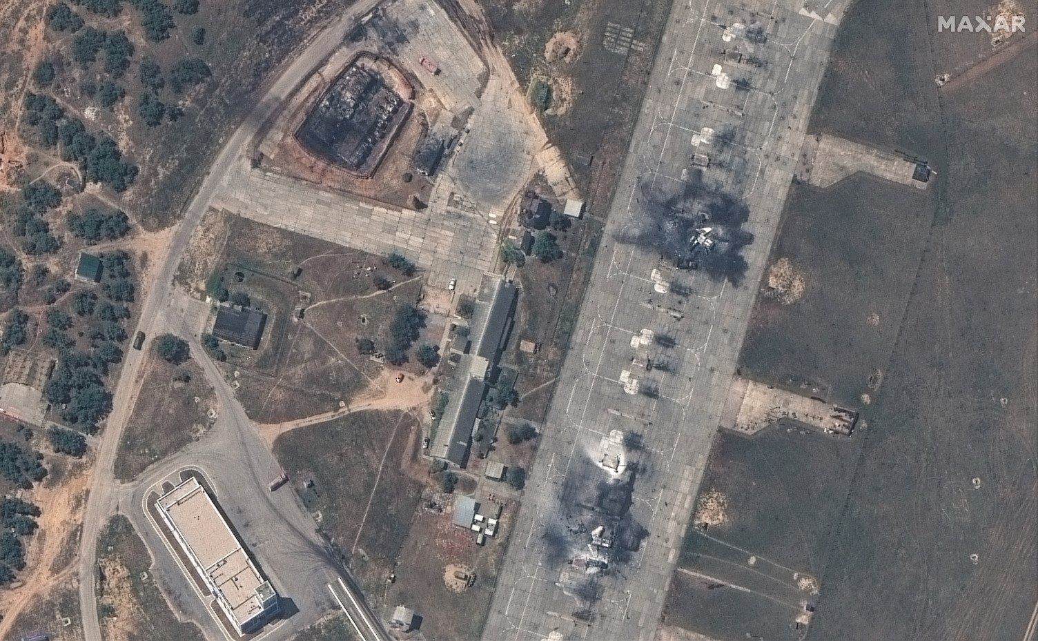
Meanwhile, the destruction of enemy equipment continued. In October, helicopters based in Berdiansk were badly burned as a result of an attack by the Ukrainian Armed Forces with ATACMS missiles.
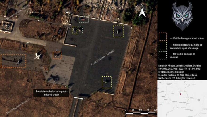
Almost simultaneously, the airfield near Luhansk was attacked.
March 24 The Ukrainian Armed Forces strike at the Russian ships Azov, Yamal, and Ivan Khurs, as well as at the communications center of the Russian Black Sea Fleet in occupied Crimea. The published images confirm that the ground facility was hit. But the situation with ships is not so simple.
In May, the Ukrainian Armed Forces attacked Belbek over two nights. ATACAMS missiles were used in the attacks. Russian officials and propagandists have traditionally claimed that air defense forces successfully intercepted all the missiles. However, satellite imagery shows that four Russian fighters were destroyed.
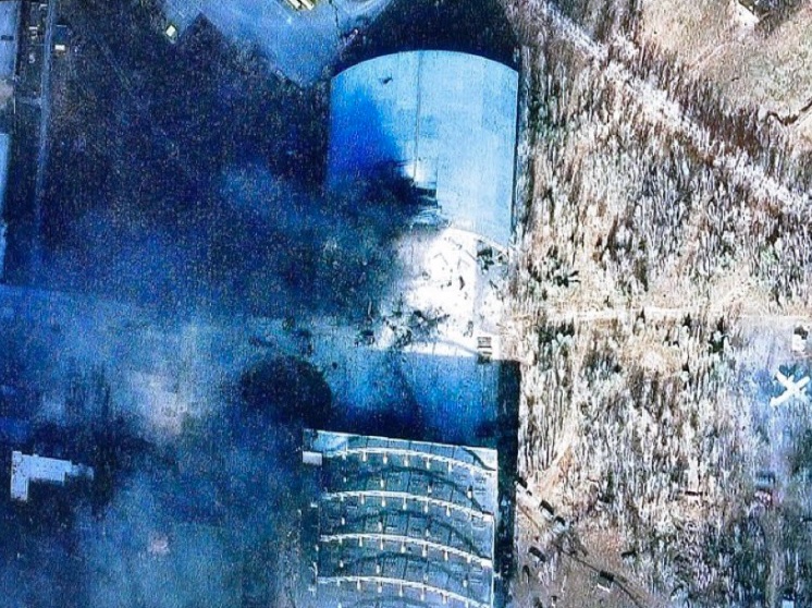
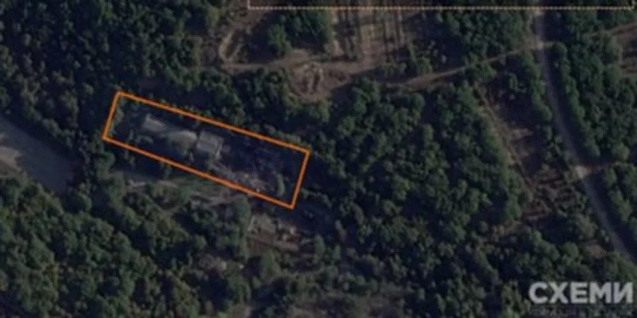
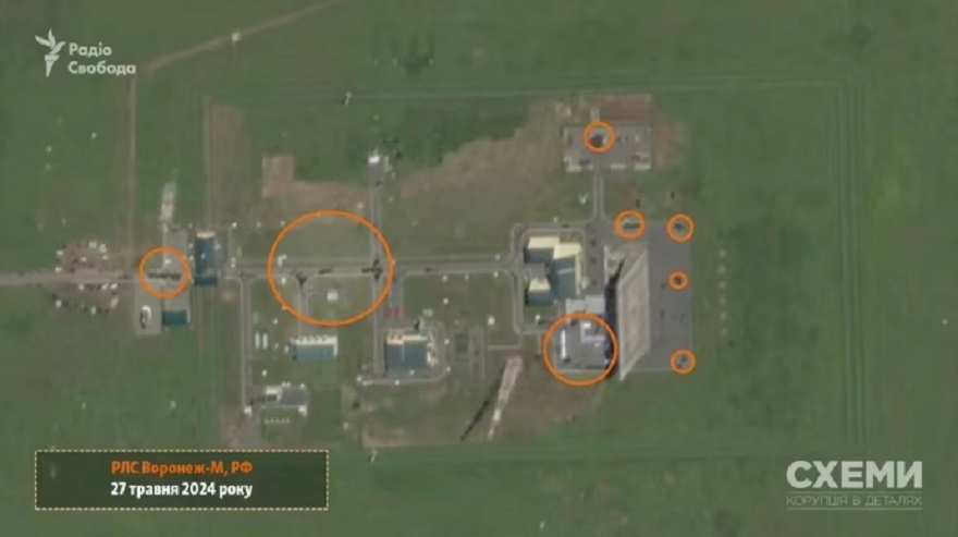
On May 27, 2024, satellite photos of the Russian Voronezh M radar station appeared online. They belong to the American company Planet Labs and were published by the Radio Liberty project Schemes. The photos show black marks on the ground, which are evidence of an explosion and fire.
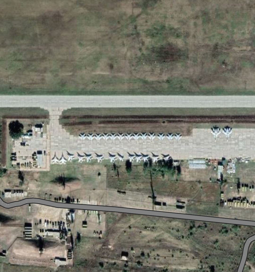
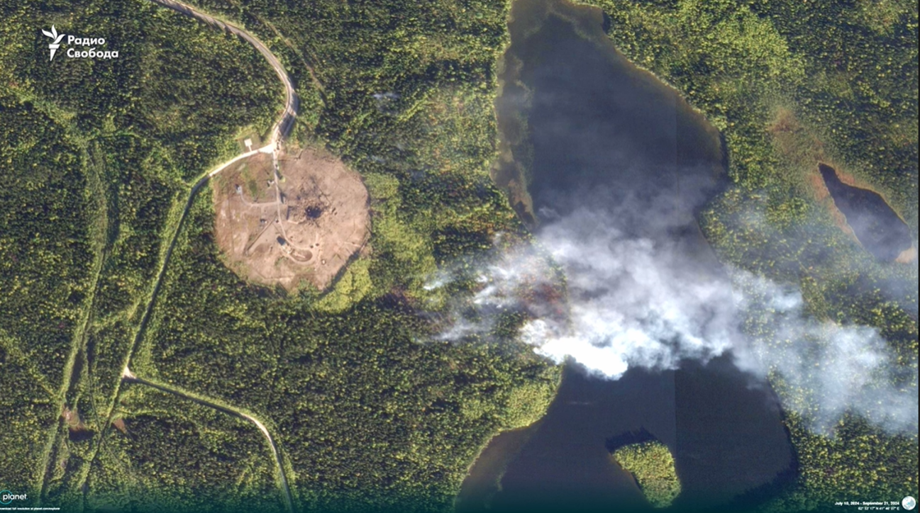
In September 2024, a new Russian Sarmat ballistic missile exploded during a test, destroying the launch complex. This is evidenced by satellite images taken by Planet and Maxar.
The winter of 2024-2025 also showed that Ukraine continues to put up fierce resistance to the aggressor. The fight continues!
