The Guardian published images of the consequences of the destruction of the Kakhovka HPP, made by satellites of Maxar Technologies. They show the catastrophic consequences of the flood, which flooded hundreds of residential buildings.
Satellite images of the disaster
Maxar Technologies is known for tracking the most important events using its satellites from the first day of Russia’s large-scale invasion of Ukraine. The Guardian has published a number of pictures taken by them, which show the terrible consequences of the explosion of the Kakhovka hydroelectric power plant, carried out by the Russian occupiers on Tuesday.


All photos come in pairs. One shows objects before the disaster. On the other is how they look now. First of all, pictures of the dam attract attention. They show two huge sinkholes, through which streams of water are still rushing, albeit not as stormy as on the first day.
They clearly indicate that it is not some kind of rocket or unauthorized destruction of the damaged structure. Such versions are still defended by Russia, which refuses to admit its guilt. And the world’s media continues to wonder what really happened.


Meanwhile, the US official representative to the UN said that although an international investigation would be needed to find out everything, in general, the blame still lies with Russia. “Why would Ukraine do this to its own territory and people, flood its land, force tens of thousands of people to leave their homes – it doesn’t make sense,” he said.
Scale of destruction
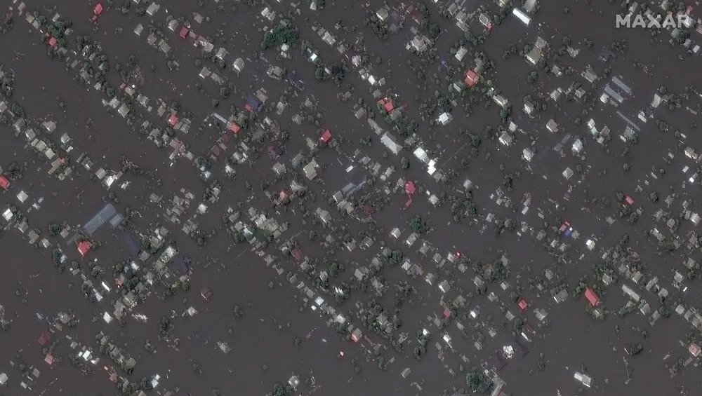
Meanwhile, the scale of destruction recorded on satellite images is impressive. Now about 100 settlements of the Kherson and Mykolaiv regions are under the threat of flooding. About 17 thousand people are forced to evacuate or hide from the flood on the roofs of their homes.


The pictures show that now you can only see muddy streams of water and buildings sticking out of it, where a few days ago there were rural streets and fields. In some of them, only the roofs are visible. The city of Oleshky was particularly badly affected. Local media report that at least three people have already died there.


Ukraine president Volodymyr Zelenskiy said that it was impossible to predict how many people would die in the Russian-occupied part of Kherson due to flooding, and called on the world for a “clear and rapid reaction” to support the victims. The global consequences for the ecology and economy of Ukraine have still to be assessed by specialists.


Perhaps satellite images will also be useful for this. Maxar Technologies reported that their photos covered more than 2,500 square kilometers between Nova Kakhovka and the Dniprovska Gulf southwest of Kherson on the Black Sea.
According to www.theguardian.com
Follow us on Twitter to get the most interesting space news in time
https://twitter.com/ust_magazine
