The volcano Mauna Loa on the main island of the Hawaiian archipelago began to erupt on November 28. NOAA satellites are closely monitoring what is happening and will warn if people are in danger.
Satellites monitor the eruption of the volcano
One of the largest volcanoes on Earth, Mauna Loa, began erupting on November 28 at 11:30 a.m. GMT+2. It is located on the main island of the Hawaiian archipelago. According to the statements of the US Geological Survey, lava flows and hot gases are now concentrated at its top and do not pose a danger to people.
However, satellites of the National Oceanic and Atmospheric Administration (NOAA) observe the eruption from orbit. And they are witnesses of its extreme power. Animated images posted on Twitter show what this event looks like through an infrared camera.
Around 11:30 p.m. HST last night, @NOAA‘s #GOESWest ????️ captured the eruption of Hawaii’s #MaunaLoa volcano, inside @Volcanoes_NPS.
This imagery shows the heat signature and the sulfur dioxide released from the #volcano‘s summit caldera, Moku‘āweoweo. pic.twitter.com/gHEG63rbLb
— NOAA Satellites (@NOAASatellites) November 28, 2022
They show not only the heat from the eruption itself, but also a thick plume of gases spreading to the northeast of the Big Island. Even later, NOAA shared another image of what was happening.
#SATELLITE SPOTLIGHT: This infrared imagery from @NOAA #GOESWest????️ caught the #eruption of the #MaunaLoa #volcano (Moku‘āweoweo caldera) on Hawaii’s Big Island overnight. NOAA’s NWS Office in Honolulu has issued an Ashfall Advisory for the island until 10 a.m. HST today. #HIwx pic.twitter.com/MR4VvJ4iO7
— NOAA Satellites – Public Affairs (@NOAASatellitePA) November 28, 2022
Can the eruption of Mauna Loa become dangerous?
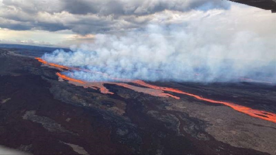
At the same time, the US Geological Survey published images of lava flows following down the northern slope of Mauna Loa. It is also known that the eruption painted the sky red. There is no direct threat to the settlements located below yet.
But the services warn that the situation may change along with weather conditions. At any moment, a change in wind direction and pressure can cause gases and ash from Mauna Loa to descend into populated areas.
Together with them, “Pele’s hair” may begin to fall to the ground. This is the name of molten basalt, which in flight takes the form of threads or fibers. If conditions worsen, the population will be advised to evacuate.
According to www.space.com
Follow us on Twitter to get the most interesting space news in time
https://twitter.com/ust_magazine
