Recently, the south pole of Mars has been attracting a lot of attention due to the secrets of hidden lakes. But the picturesque north pole of the planet also has its unsolved mysteries. A new 3D radar image of the pole shows what lies beneath its surface.

A team of researchers from the Institute of Planetary Sciences used radar data collected by NASA’s Mars Reconnaissance Orbiter to create a new polar map. The results revealed previously unknown objects, such as an impact crater and a hidden canyon.
The hidden canyon will help to better understand the polar geology and its connection with the history of the climate of the Red Planet. Earth and Mars are rocky planets, but they have traveled completely different paths. Scientists are trying to solve the mystery of why Mars has become the inhospitable place it is today.
Shallow Radar
MRO is equipped with a Shallow Radar device that reflects radar waves under the surface of Mars, which allows scientists to “look” under the surface of the planet. Scientists processed this data and created a 3D map of the subsurface. The researchers published their work in The Planetary Science Journal.
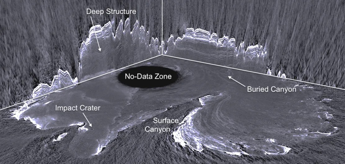
Shallow Radar was designed to search for liquid or frozen water. But the reflected radar waves also show what happens to rocks and sand. This helps scientists get a picture of how geological layers were deposited and eroded at the pole.
Light touch of history
A three-dimensional map is just the beginning of the story. According to scientists, the discovery has allowed only a “slight touch” to the history of polar processes on the planet, and there is still a lot of detailed cartographic work ahead.
Next, the researchers intend to identify more buried impact craters and evaluate the subsurface structures appearing in the image. The same process that is used to create a polar radar image can also be effective for showing what is happening in other regions of the planet. The beauty and intrigue of Mars are not only on the surface – clues about its history are hidden deeper.
Earlier we reported on how MRO captured dry ice on Mars.
Follow us on Twitter to get the most interesting space news in time
https://twitter.com/ust_magazine
