Russia’s military intervention in Ukraine, which began on February 24, 2022, threatened 40 million lives in Europe’s largest country. As a result, we have destroyed cities, civilian casualties and over a million refugees — the peace-loving Ukrainian people have fully felt the full burden of the “Russkiy Mir” (Russian World).
However, the Ukrainian struggle continues. In addition, to the surprise of many, the private space sector began to take an active part in it. The Global Earth Observation System of Systems (GEOSS) equipped with synthetic aperture radars (SAR) has turned into the sharp eyes of Ukrainian intelligence. Every day, they provide the Ukrainian military with the most up-to-date information about the movement of military columns of the occupation troops, as well as help in organizing humanitarian missions. This material is dedicated to peaceful technology, which in wartime conditions comes to the defense of the Ukrainian people from Russian aggression.
Basic operation of SAR satellites
The original purpose of SAR satellites is to monitor the Earth’s surface, observe weather and climate changes.
The principle of SAR operation is based on the technology of two- and three-dimensional mapping of the landscape using radiation and reception of a radio signal reflected from the Earth. When the satellite moves in orbit, radio waves reflected from the land surface, are transmitted to the receiving antenna in real time, they are recorded and compared with each other, and then transformed into visual images using software (such as ENVI).
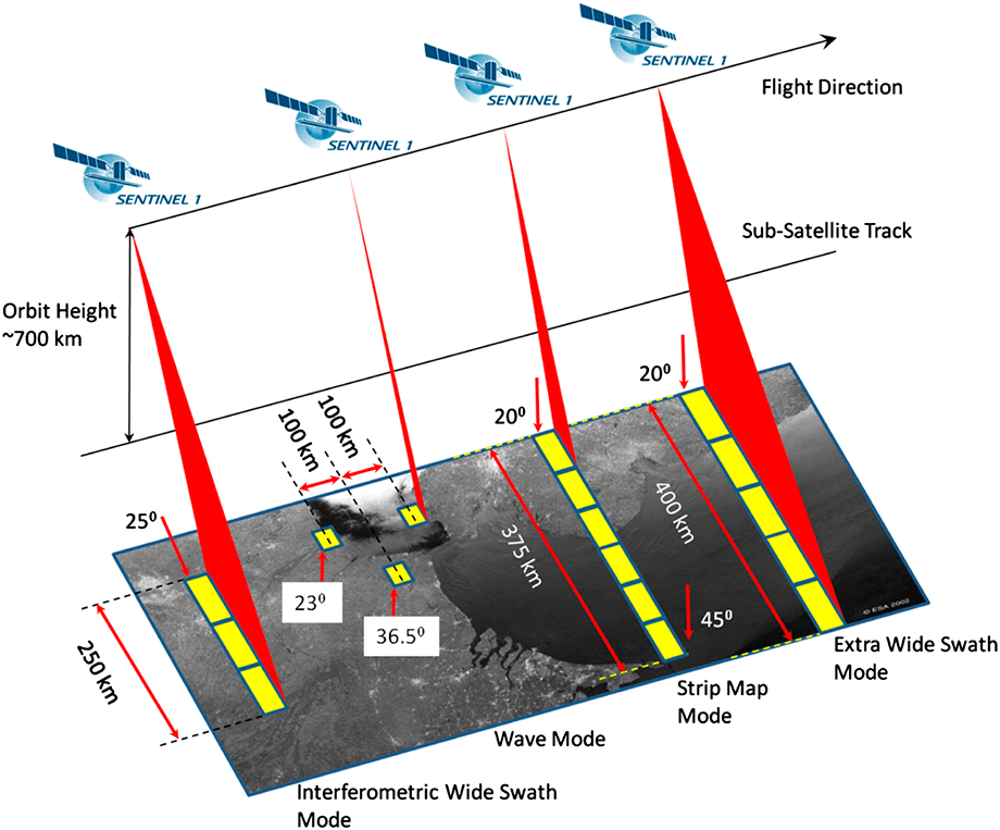
The technology of synthetic aperture radars is unique due to many factors:
- Since the SAR operation is based on the principle of radio wave signal reception, landscape monitoring can be carried out under any weather conditions and time of day.
- When using SAR satellite groupings, it is possible to obtain a 3D image of the probed landscape, but this is impossible if optical satellite cameras are used.
- The use of Interferometric synthetic aperture radars (InSAR) makes it possible to receive information about geodetic processes (movement of the Earth’s crust, volcanic activity), and during hostilities — to localize the places of destruction and promptly assess the situation. Interferometric scanning of the landscape provides data on thermal radiation from the operating engines of armored vehicles, vehicles and supply trucks of the aggressor.
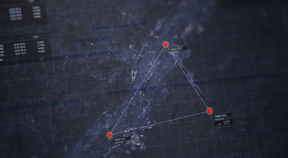
The role of SAR satellites in intelligence
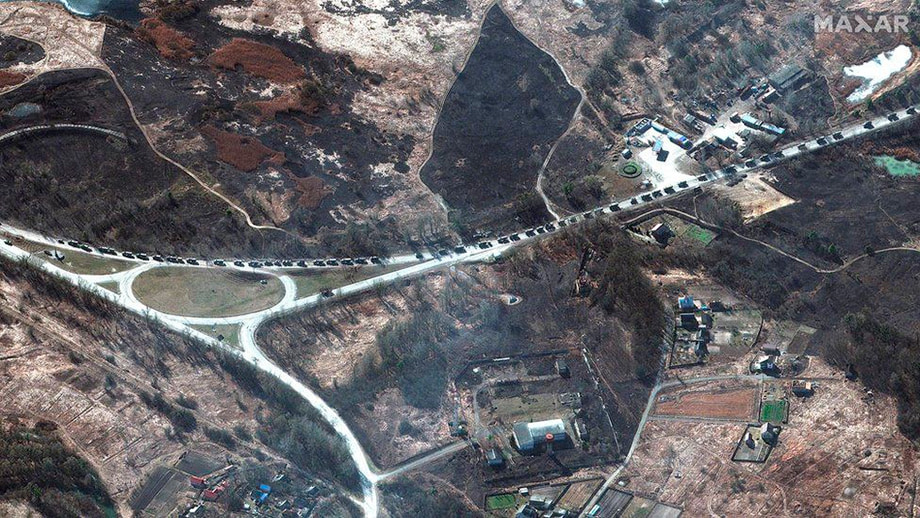
The first bunching-up of Russian military convoys heading to the Ukrainian border was noticed by a professor of the Middlebury Institute of International Studies (MIIS) on the night of February 24. He received this data using the Capella Space search and rescue monitoring satellite and immediately noticed the offensive nature of the column’s movement: the military hardware was on the march movement and formed a 40 km long traffic jam. Satellite data directly indicated the beginning of military aggression against Ukraine. A few hours later, reports of the first border clashes began to appear in the Ukrainian information field.
Todd Humphries, professor at the University of Texas, believes that about 50 commercial SAR satellites are regularly circling in the sky over Ukraine. The intelligence information gathered by satellites has a direct impact on the success of the Ukrainian defensive operation, since it allows forecasting the direction of possible armored attacks actually a few hours before they begin. Due to this, Ukrainian troops can concentrate their defense reserves in these areas. Intelligence information coming from SAR satellites is also used to coordinate Bayraktar, Turkish automated attack drones, purchased by the UAF in Turkey.
The aggression of the Russian Federation has become a personal tragedy for businessman of Ukrainian origin Max Poliakov, head of EOS Data Analytics (EOSDA). On March 1, he appealed to the heads of all commercial satellite companies to provide the Government of Ukraine with objective satellite data regarding the movement of Russian occupation troops. EOSDA provides similar data not only to military departments, but also to humanitarian organizations involved in the rescue of the civilian population of Ukraine. Poliakov’s appeal was addressed to the European, Canadian and German space agencies and companies such as IAI, Iceyer, Capella, Planet, MAXAR, Airbus, SIIS, Space View, Blacksky.
“The economic, political and humanitarian consequences of the war in Ukraine are already too high to stand aside. If you can help us, please provide the SAR data that are relevant now, but not archived or outdated optical images, suitable only for PR purposes and as proof of war crimes for future international trials.” — suggested Max Poliakov during his briefing.
Importance of firm position and deadly passivity
Currently, satellite systems, equipped with synthetic aperture radars, are used for dual purposes for both civilian and military purposes. It is essential that the aggressor country, represented by the Russian Federation, does not have such an effective resource: All its intelligence activities are carried out mainly via UAVs that turn out to be vulnerable to electronic warfare (EW).
The support of commercial space companies and their indirect participation in the military conflict on the side of Ukraine began to cause concern among investors and heads of such companies, who do not want to involve peaceful technologies in solving military tasks. However, the terrorist methods of waging war by the Russian occupation forces (firing by multiple launch rocket system and aerial bombing of residential areas) make this problem an issue of human rights protection.
Now, the official authorities of Ukraine continue to call on private aerospace companies to help in providing satellite intelligence data. The reality is that today the participation of SAR satellites in the defensive war of our country not only saves the lives of ordinary peaceful Ukrainians, but also actually contributes to the security of the entire European continent.
The amorphousness and disinterest in this problem of the leaders of some EOS companies can lead to catastrophic consequences. More precisely, this inaction is described by the words of the German Protestant pastor and theologian Martin Niemoller, who explains the silence of the German intellectual elites during the genocide committed by Nazi Germany in 1933-1945:
“First they came for the socialists, and I did not speak out —
Because I was not a socialist.
Then they came for the trade unionists, and I did not speak out —
Because I was not a trade unionist.
Then they came for the Jews, and I did not speak out —
Because I was not a Jew.
Then they came for me — and there was no one left to speak for me.”
According to https://maxpolyakov.com
