
Participants in the NASA-funded SWIM (Subsurface Water Ice Mapping) project published a new set of maps. They demonstrate the distribution of water ice deposits under the Martian surface.
Where to look for ice on Mars?
Ice will become a vital resource for the first people to reach the Red Planet. It will provide them with water, oxygen and rocket fuel components. In addition, ice is an important object of research. Astronauts will be able to take cores and study how the planet’s climate has changed in the past. It is also possible that they would be able to shed light on whether Mars was ever inhabited.

But where exactly should we look for ice on Mars? The planet’s atmosphere is so thin that any liquid water will immediately evaporate. Open ice deposits at the equator will suffer the same fate. There are large accumulations of water ice at the Martian poles, but these areas are too cold for astronauts or robots to stay there for a long time.
Fortunately, the data collected by the spacecraft indicates that there are subsurface deposits of water ice in many parts of Mars. The middle latitudes of the Northern Hemisphere are attractive in this regard. Due to the lower surface level, the atmosphere above them is thicker than in most other places on the planet, which facilitates the braking of the descent vehicles. The ideal place to land a manned expedition would be at the southernmost edge of this region — far enough to the north that ice could already be present there, but close enough to the equator to provide the warmest temperatures for astronauts.
Map of Martian ice deposits
That is why this region is the subject of the SWIM project. It has recently released a new and most detailed set of maps showing the distribution of water ice deposits on Mars.
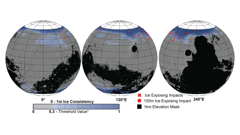
Previous versions of the map used lower-resolution images as well as data obtained by radars and spectrometers installed on Mars-exploring spacecraft. When compiling the new version, scientists for the first time used two cameras with higher resolution installed on board the MRO probe. The Context Camera data allowed scientists to refine the maps of the Northern Hemisphere, and the HiRISE camera data allowed them to determine the limits of ice occurrence. Recently formed craters were used for this purpose. So, in 2022, HiRISE discovered a fresh 150-meter impact formation that exposed ice deposits.
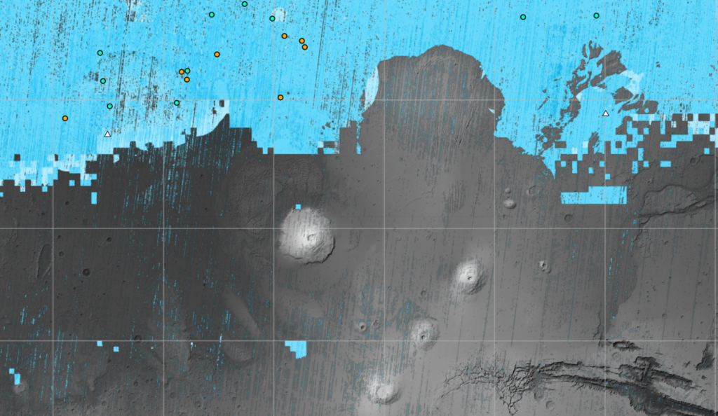
Thanks to HiRISE, so-called polygonal reliefs were also discovered. They occur when polygonal cracks form in the ground as a result of the seasonal expansion and compression of subsurface ice.The presence of such polygons around fresh, ice-filled impact craters is another piece of evidence that even more ice is hidden under the surface in these places.
According to https://www.nasa.gov
Follow us on Twitter to get the most interesting space news in time
https://twitter.com/ust_magazine
