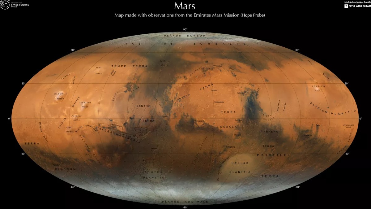
A new map of Mars shows the Red Planet in stunning detail, revealing many fascinating geological features visible from orbit. The high-resolution map would help scientists answer a number of pressing questions about Mars, in particular how it became a dry, arid and barren landscape despite the fact that it was once rich in liquid water.
The map of Mars was created by a group of scientists led by New York University Abu Dhabi (NYUAD) and the United Arab Emirates (UAE) Center for Space Science (UAE). The researchers used data collected from orbit around Mars as part of the Emirates Mars Mission (EMM), also known as Hope or “Al-Amal”. The map shows the Red Planet through the “eyes” of the modern Emirates Exploration Imager (EXI) onboard imaging system.
To create a detailed map of the surface, more than 3,000 EXI observations were made during one Martian year, i.e. a period equivalent to two years on Earth. Then all the pictures are combined together to create a color composition. The resulting map shows many of the main geological features of the Red Planet in high resolution.

Polar ice caps, mountains and long inactive volcanoes are visible on the map, and also the remains of ancient rivers, lakes and valleys that were overflowing with liquid water about 3.5 billion years ago. In this way, the map can help planetary scientists better understand how the climate of Mars has changed over billions of years, leading to the dry and barren world we see today.
The Al-Amal orbiter is the first interplanetary mission in the UAE and the Arab world as a whole. By order of the UAE leaders in 2014, the spacecraft was launched from Japan on July 20, 2020. After about a seven-month journey, Hope successfully reached the orbit of Mars on February 9, 2021. Now it is working there.
According to Space
Follow us on Twitter to get the most interesting space news in time
https://twitter.com/ust_magazine

