
Satellite images of the crash site of the Russian military transport aircraft Il-76, which occurred on January 24 this year near the village of Yablonovo, Belgorod Oblast, appeared on the website of the Schemes project (Radio Liberty). They were taken on January 31 by the Planet Labs spacecraft. The resolution of the photos is not enough to draw conclusions about the cargo of the aircraft, but it is obvious that it was moving to the northeast.
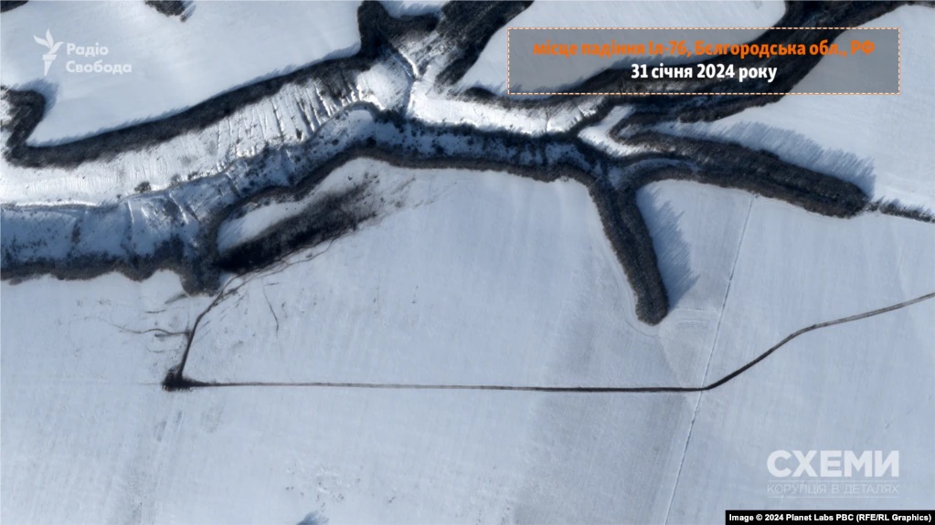
The aircraft collided with the ground at coordinates 50°53’34” north latitude, 37°20’22” east longitude, near the edge of a deep ravine. After that, it collapsed, and its fragments continued to move and left a gradually expanding dark strip of almost 500 m long on the snow-covered field. This may indicate that the fall was not accompanied by a powerful explosion that would have scattered debris in a direction perpendicular to the flight path. In the photo, you can see numerous traces of special equipment and search service personnel who conducted a survey of the remains within a week from the moment of the fall.
Crash site of Russian Il-76 airplane near #Yablonovo, #Belgorod Oblast.
— kosmi ????️???? (@kosmi64833127) January 30, 2024
The scar is ~450 meters long ????????
Images taken by #Landsat-8/9 on Jan 13 and today.@Artur_Micek @bradyafr @tom_bike #Russia #Il76 #UkraineRussiaWar #Ukrainewar #war pic.twitter.com/3EKcXq2ea1
The journalists also reported that they had managed to identify the names of five Il-76 crew members. These are commander Stanislav Bezzubkin, navigator Alexei Vysokin, flight engineer Andrei Piluev and Sergei Zhitenev, as well as assistant commander Vadim Chmirev. The deaths of three of them have already been confirmed by relatives. All of these are military personnel of the 117th Military Transport Aviation Regiment based in the Orenburg Oblast.
Earlier, we wrote about what a full-scale Russian-Ukrainian war looks like on satellite images.
Follow us on Twitter to get the most interesting space news in time
https://twitter.com/ust_magazi
