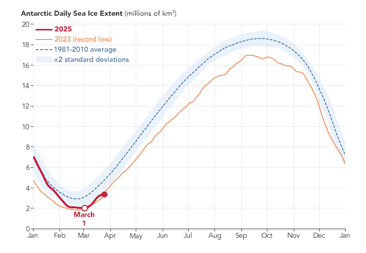
NASA and the National Snow and Ice Data Center (NSIDC) have released observations of sea ice in Antarctica. Its area reached the second lowest level in the 47-year history of satellite measurements.

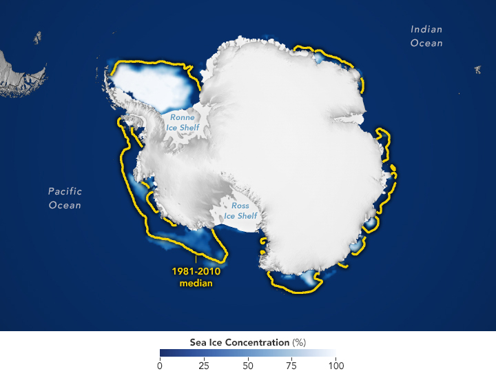
NASA’s map shows the extent of sea ice in Antarctica as of March 1, 2025 (in the Southern Hemisphere, this corresponds to the end of summer). By that date, it had fallen to 1.98 million km2, 30% below the 1981-2010 average of 2.84 million km2. Sea ice loss is comparable to the area of Pakistan.
Sea ice area is defined as the total area where the ice concentration is at least 15%. The yellow outline of the map indicates the average ice extent for 1981-2010 for February. The median is the mean value. In other words, half of the area occupied by ice was larger than the yellow line and half was smaller.
“It is still unclear whether the Southern Hemisphere has entered a new normal with multi-year low ice levels or whether Antarctica is in a transitional phase that will return to previous levels in the coming years,” said Walt Meier, an ice resource specialist at NSIDC.

In their analysis, the scientists rely heavily on the Defense Meteorological Satellite Program (DMSP), which measures the Earth’s radiation in the microwave range. This natural radiation is different for open water and for sea ice, with the ice cover standing out clearly in satellite microwave images. Microwave scanners can also penetrate through cloud cover, allowing for daily global observations. The DMSP measurements are supplemented with historical sources, including data collected between 1978 and 1985 by the Nimbus-7 satellite.
While sea ice in the Antarctic reached its summer minimum, winter sea ice extent in the Arctic approached the lowest level in the history of satellite observations. Globally, ice extent in mid-February this year was down by more than 2.5 million km2 compared to the pre-2010 average. In total, the Earth lost sea ice larger than the area of Greenland.
Earlier we reported on how satellites recorded an increase in vegetation in Antarctica.
According to Earthobservatory


