
Mars was once much wetter and had glaciers on its surface. However, they did not just lie on the surface, but moved slowly across it, just as on Earth. Scientists investigated this process by the landform features that the ice left behind.
Glacial activity on Mars
The surface of Mars is known as an extremely cold, desiccated and irradiated place. But as numerous surface features show, the red planet was once a warmer, wetter place with running water and glaciers. Today, most of the water remaining on the surface belongs mostly to the polar regions in the form of ice caps, permafrost and underground glaciers. However, the seasonal melting and freezing of this ice still impacts the Martian environment and provides clues about past glacial activity.
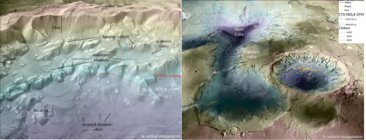
In a recent paper, a team of scientists from the Planetary Science Institute (PSI) investigated the melting of subglaciers in and around a medium-sized crater in the northern Arabia Terra region and a neighboring depression, the Heart Lake System.
Based on multiple lines of evidence, they hypothesize that a retreating regional glacier created the depression. They also claimed that the melting of a subglacier formed shallow channels in the region, leaving behind a proglacial lake with smaller glacial deposits inside the crater, leading to further meltwater and lake formation.
The paper was the topic of a presentation at the 2025 Lunar and Planetary Science Conference held on March 10-14, 2025, in The Woodlands, Texas. Its authors are Dan Berman and Dr. Rebecca M. E. Williams, two senior researchers at PSI.
Formation of terrain relief by glaciers
As they note in their paper, the features that form with glaciers have been studied on Mars since the Viking missions in the 1970s. These features have been interpreted as debris-covered glaciers because of their shape, which consists of lobe-shaped patterns, deformation features, and surface textures such as linear structures, cracks, and pits. They are also followed by terminal moraines, cross-shaped clusters of glacial debris that indicate they are experiencing ice loss.
These glaciers are thought to have a “cold base,” meaning that there is no melting at their base that would favor sliding, as signs of melting, such as meltwater channels and eskers, are not commonly observed in their vicinity. These features are thought to have formed several hundred million years ago, indicating that conditions at that time were too cold for ice to melt. Recent observations have pointed to several regions on Mars with potential eskers beyond viscous flows, but the origin of these ridges is still debated.
Use of GIS technologies for glacier research
These recent signs and hydrologic models indicate that wet glaciation is possible, despite the limited evidence for subglacial melting. To solve this problem, Berman and Williams mapped these features using geographic information system (GIS) technology. They also built digital elevation models (DEMs) from the global CTX model and images taken by the Context Camera (CTX) and the High Resolution Imaging Science Experiment (HiRISE) on NASA’s Mars Reconnaissance Orbiter (MRO).
Their study focused on the region in and around the 48-km (30-mile) diameter crater in northern Arabia Land and the neighboring Heart Lake System. As Berman explained, this crater was previously identified as a potential paleolake with numerous features indicating wet subglacial melting.
Results of the study
Using GIS and DTMs,, Berman and Williams analyzed the topography and slopes of these targets. Their results suggest that some of the valleys and ridges may have risen, indicating that they may be of glacial origin. That is, Mars may have been warmer than previously thought during the early Amazonian period of the planet’s modern geologic era, which began 2.9 billion years ago. This could have significant consequences for understanding the geologic evolution of Mars and help resolve the open question of when Mars lost water.
This opens the way for future research when robotic and manned missions will be able to observe these features to determine if they were formed by melting ice.
According to phys.org
