The global positioning system is increasingly integrated into our daily lives. Today, it is difficult to imagine the effective use of troops without data from satellite navigation systems. At the same time, there are some risks, because in the event of an armed conflict during the destruction of the positioning apparatus, the army and the civilian population will be disoriented and suffer certain losses. The media is already full of reports of attacks on GPS signals. In order to minimize risks, the world’s leading countries are actively developing, improving their own global navigation systems and implementing new opportunities.
Today’s threats
The convenience and comfort of modern civilization are to some extent associated with a number of risks. For example, failure or lack of navigation signal from our usual GPS can lead to incorrect location of the object. Undoubtedly, this will create chaos in the work of air and sea transport, delivery services of consumer goods, and will affect the functions of smartphones. Thus, the enemy can weaken the country without involving any soldiers. That is why the topic of navigation safety is a matter of national importance.
It has become especially relevant recently, after Russia blocked GPS signals. For the first time, the illegal and provocative activities of the Russians were confirmed during the “West-2017” exercises, which took place near the Baltics, then repeated in October-November 2018 as part of the joint NATO exercise “Single Trident” in Norway.At the West 2017, the Russian Federation focused on working out the actions of the military in the event of both local and wider escalation, with a clear bias towards the concept of deterring the enemy A2AD (anti-access and area denial); electronic means of warfare designed to create failures outside the designated test areas were actively used. As a result, there were malfunctions in civilian communications and navigation systems, including GPS, in remote regions of Latvia and in the Norwegian Finnmark.

Following the completion of NATO’s Single Trident exercise, the Norwegian Ministry of Defense has publicly accused Russia of involvement in GPS failures in the Kola Peninsula. For his part, the Prime Minister of Finland said that the obstacles to the navigation signal were created intentionally and that Russia was probably behind it. Lapland and the northern territories of Norway near the Russian border have been negatively affected. Later, in the spring of 2019, the American non-governmental company C4ADS stated that Moscow is using technologies to disorient the GPS satellite navigation system in the occupied Crimea. According to a scientific sensor from the International Space Station, the organization was able to identify activities that pose a significant threat to GPS systems of civil airlines in the region. In addition, analysts have identified many obstacles to the operation of the Global Navigation Satellite System GNSS in Russia, the occupied territories of Ukraine and military facilities abroad. A total of 9,883 cases of Russian GNSS interference in 10 locations were identified, which affected the navigation systems of 1,311 civilian ships. Researchers also recorded failures of GPS signals in areas where Russia is conducting active hostilities, including Syria.
Russia explained the situation in its own way. In Moscow, for example, they do not trust the information of the American navigation system. According to Major General Anatoly Nestechuk, Chief of Staff of the 15th Army of the Russian Air and Space Forces, “analysis of recent armed conflicts has shown that the enemy is actively using the possibility of deliberate amendments to navigation data as a means of disinformation. So can’t rely on the information coming from GPS receivers “.
It is worth noting that the creation of glitches for enemy navigation tools is pretty yummy not only for Russia. In practice, this has been used effectively to counteract cruise missile control during US and British operations in Iraq, as well as NATO’s “Deliberate Force” in the Federal Republic of Yugoslavia. This led to the self-destruction of cruise missiles, as well as to their abnormal flight on an unauthorized trajectory.
Appropriate steps
Understanding of such risks, as well as mutual mistrust, has long contributed to the development of certain satellite navigation systems — American NAVSTAR GPS, European Galileo, Chinese Beidou / Compass and Russian GLONASS. They are all used by the army.
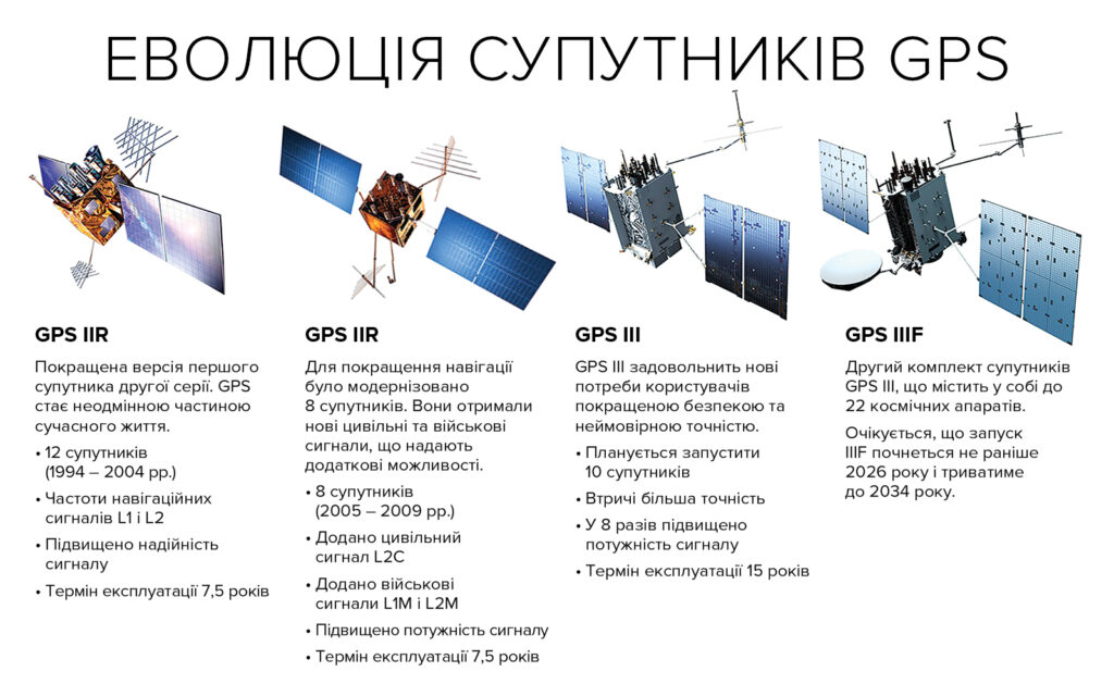
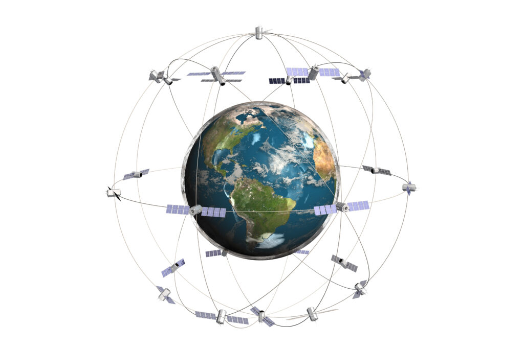
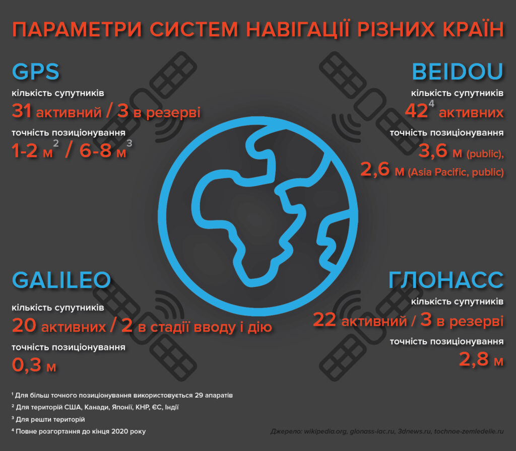
There is currently no objective answer which system is better. However, the most common, of course, is the American NAVSTAR GPS. It consists of 32 spacecraft orbiting in six orbital planes at an altitude of 20,183 km. As of July 2019, 31 satellites are being used for their intended purpose and only one is under maintenance. The typical accuracy of modern GPS receivers is about 6-8 meters. WAAS, EGNOS, MSAS stations are located in the USA, Canada, Japan, China, the European Union and India, which transmit corrections for the differential mode, which allows to reduce the error to 1-2 meters. When using more complex modes, the accuracy of coordinate determination can be increased to 10 cm. The system is characterized by maximum reliability and is constantly updated. For example, as of September 2018, twelve satellites of the new version of GPS IIF have been launched into orbit.
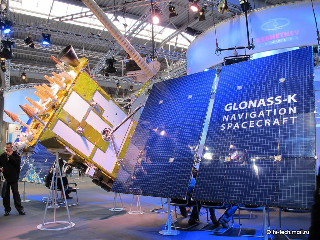
Орбітальне угруповання російської системи ГЛОНАСС на сьогодні представлене 26 апаратами, 24 з яких використовується за цільовим призначенням. Цього достатньо для повного покриття Землі навігаційними сигналами. Водночас, судячи з повідомлень офіційних російських джерел, у системи дуже багато проблем. Значна частина апаратів уже відпрацювала гарантійний термін. Щодо надійності теж виникають питання. Так, 2 квітня 2014 року трапився великий збій у роботі системи ГЛОНАСС. Упродовж майже 11 годин усі 24 супутники видавали некоректні дані, тобто система виявилася непрацездатною. Несправність усунули, але питання, чи можливе повторення подібних ситуацій, залишається актуальним.
Galileo’s European global satellite system is compatible with GPS and GLONASS navigators, but unlike them is not controlled by the military. Since 2008, it has been allowed to be used in military operations to ensure European security. The orbital group of the navigation system has 26 satellites, of which 22 are operational. In addition to the EU, the development was funded by China, Israel, Ukraine and South Korea. The system is designed to solve navigation tasks for any moving object with an accuracy of less than one meter. The cost of the project is about 5 billion euros. Galileo is still in the deployment phase. It is planned to be completed by 2020, but is already being used as intended. In July 2019, the system crashed due to a malfunction of the ground station in Italy, which is responsible for transmitting the exact time.
China claims the position of one of the world’s major superpowers and is actively implementing its own satellite navigation system Beidou. China explains this step by the rapid development of technology, as well as the desire not to depend on American GPS.
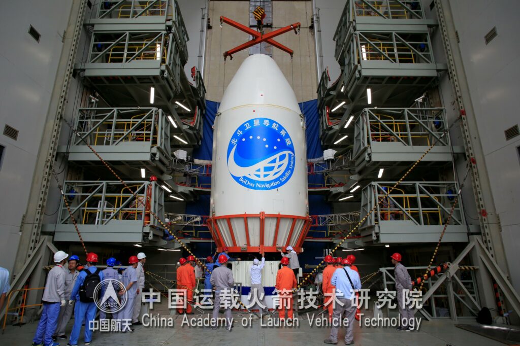
On June 23, 2020, China launched the last, 59th satellite of the system. 35 of them are currently used for their intended purpose. Beidou is considered the only rival for the United States. Since 1989, it has passed three generations, and Beidou-3 is considered a direct competitor to the American GPS, European Galileo and Russian GLONASS. The Beidou-3 system will have 27 Beidou-M satellites in mid-circular orbit, five Beidou-G in geostationary orbit and three more Beidou-IGSOs in geosynchronous inclined high orbits. Satellites have a long service life. The element base allows the former to work in space for about 12 years, the latter — up to 15 years. Chinese devices are superior to Russian GLONASS-M with a service life of 7 years and GLONASS-K with a warranty of 10 years. At the same time, according to official data, the accuracy of determining the coordinates of the object for the military sphere by the Beidou system is up to 2 m, for civilians — up to 10 m. Earlier, China launched another satellite of the Beidou — Qianqin II navigation system into near Earth orbit, which uses an electronic chip that allows you to determine the coordinates of the object with minimal error.
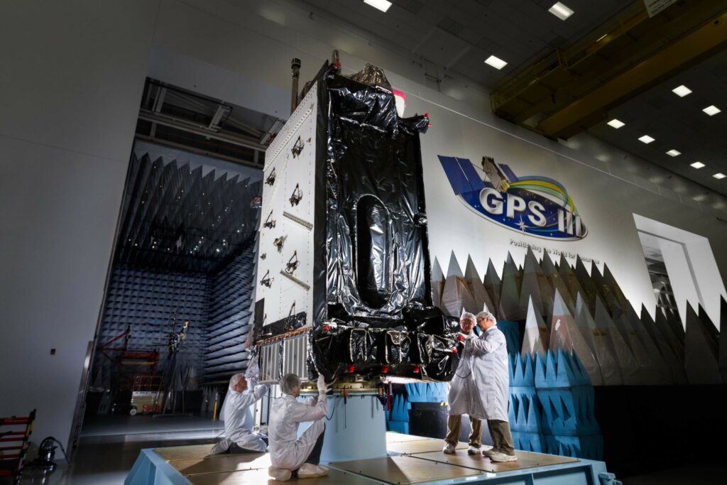
So, in the near future there will be a serious struggle for consumers between the Chinese Beidou and the American GPS. Meanwhile the United States is unlikely to give up a place in the market, where for a long time the country was a monopolist. That is why Washington has long been working to develop a new system of global positioning. On October 1, 2019, the press service of the American corporation Raytheon published a statement on the completion of the process of creating a new generation of GPS, known as GPS OCX. The new GPS OCX (Block 0) launch and cybersecurity testing system was already used in 2018-2019 to launch the first upgraded GPS III satellite. It will provide increased accuracy and coverage in hard to reach places. According to the company, the launch of the new generation of Block 1 should take place in 2022. The report states that the hardware and software have already been developed. Raytheon specialists have started testing it, as well as integrating it with the equipment of the already deployed global positioning system.
Current trends help us predict the further development of GPS and point to their special significance for leading states and alliances. At the same time, every country, understanding the risks and security threats associated with the disruption of foreign systems, whose services they have to use, is trying to develop their own GPS, resistant to active interference. In addition, the search for new technical solutions is underway. For example, recently, after a series of crashes and glitches in the GPS navigation system, the US Armed Forces and several US laboratories announced the creation of a new quantum program that could completely change global search engines, eliminating their need for satellites. And Volkswagen has announced plans to run a field testing of a navigator that works with quantum computing. According to the company, this is the first such experiment in the world to optimize traffic.

Who knows, maybe the role of satellite global positioning will soon decrease… But one thing is clear: the desire of developed countries to be independent in obtaining accurate coordinates will continue to grow.
